
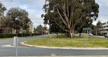
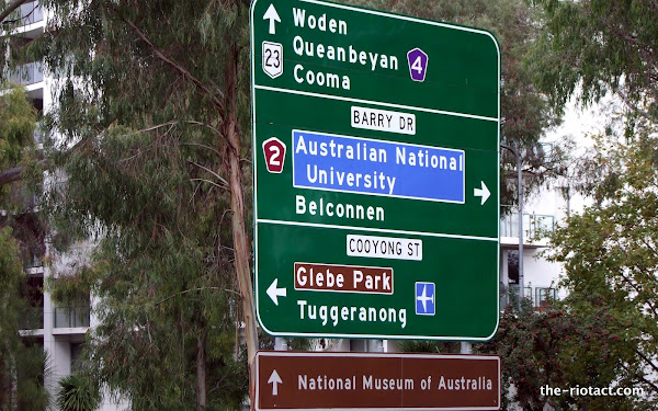
Walking down Northbourne this arvo something about the large roadsign on the southbound side just before Cooyong St / Barry Drive caught my attention. This says:
- Straight ahead: Woden, Queanbeyan, Cooma
- Right turn: Belconnen
- Left turn: Glebe Park, Tuggeranong
What? Straight ahead for Cooma but turn left for Tuggers? Does this make sense to any RAers?
The left turn takes you to Parks Way which is the quickest way to Tuggeranong. Although you could go forward and then cut through new Acton as well.
winter said :
Yes, of course.
By the way, which would be the quickest way to Cooma from that sign?
Holden Caulfield said :
Really clutching at straws, but maybe Adelaide Ave/Yamba then Hindmarsh to Monaro is what they are suggesting??
It’s not an error, but is misleading in some ways. We live in Tuggers and when trying to explain the quickest way to get to us, we actually get people to turn off towards Majura and hit the Monaro.
There’s another sign as you go down towards Woden that tells unsuspecting newbies to town to leave the road and take the Cotter turn off to get to Tuggeranong – when you could just stay on the same road and get there in exactly the same timeframe – if not quicker as the new sign takes you eventually to the Tuggers Parkway which may or may not have it’s seemingly daily accident happening.
My Mother in law and sister in law are the worst offenders in the world for not following our directions and getting taken in by these signs – even though we say repeatedly “IGNORE THE SIGNS”.
winter said :
Very good. There’s even a sign at the big roundabout on Parkes Way indicating which way to Tuggers.
Holden Caulfield said :
I would have said Parkes Way / Morshead Dve on to Monaro Hwy as there are less traffic lights that way.
winter said :
“……”The left turn takes you to Parks Way which is the quickest way to Tuggeranong. Although you could go forward and then cut through new Acton as well.”
Yes, of course.
By the way, which would be the quickest way to Cooma from that sign?……”
I guess it is suggesting Commo Ave, State Ccl, Canberra Ave and Monaro Hwy
Of course the actual fastest way to Tuggeranong from that sign is to turn right, then left onto Clunies Ross, avoiding the traffic lights controlling the Canberra Centre parking and scoring a drive past the Botanic Gardens and Yarramundi Reach as a bonus. Shaves two to six minutes off the travel time, assuming road rules are observed. The signposted route is longer by a few minutes but is easier for visitors to navigate,
Quickest way to Cooma from that sign is the signposted route via Commonwealth Avenue, through Manuka, past the railway station, to the Monaro Highway.
Any notion of time is speculative; you could go any of the three directions and get to Tuggeranong before too long, and the equation comes down to which part of Tuggeranong you’re heading for anyway.
I would assume speed isn’t the guiding factor, but simplicity. For visitors (who must be the main target audience for signs like this) it seems to me that straight ahead would be the better option, as that route takes you directly to Tuggeranong without turning again (although you would have to watch the signs at the mildly confusing Woden roundabout in order to stay on Yamba Drive). Turning left is almost as good, as it requires only one turn, a veering left at Glenloch and the right turns to Tuggeranong Town Centre are hard to miss. Turning right and taking Clunies Ross might be quicker, but not as easy as the other two options if you’re not familiar with the roads.
And if you wanted to take the scenic route, you could make a u-turn, head up the Barton Highway, down the Hume, do a lap of Melbourne using the M80 and M1, east along the Prince’s Highway, hang a left at Cann River and arrive at Tuggeranong from the other direction
madamcholet said :
Might be just me. But after 1.5 years, I still find the merge from Cotter Road to Tuggeranong Parkway to be fairly dangerous. Not a good way to introduce newcomers to Canberra.
Map: http://g.co/maps/vkfa9
FioBla said :
It’s suggesting straight ahead to Cooma going down Commonwealth Avenue, Capital Circle, Canberra Avenue, Monaro Highway. This is following National Route 23.
It’s suggesting left to Tuggeranong going down Cooyong St, right at Parkes Way then down the Tuggeranong Parkway – note that it’s heading for the Tuggeranong Town Centre.
caf said :
I think that’s the best explanation so far.
Not needing to travel to Cooma or Tuggeranong all that often I had assumed it was sending Tuggeranong traffic to Monaro Hwy, via Parkes Way, in which case this would make as much sense to direct Cooma traffic the same way.
FWIW, Google says it is 8.2km/13min to get to the Monaro Hwy via Comm Ave/King Edward Tce and 9.6km/14 min to go via Parkes Way/Morshead Drive.
Lucky we’re solving the big issues here on RA!
I think putting a four-way arrow to indicate the many different ways to Tuggeranong could prove a little confusing for motorists..
Why would you want to go to Tuggeranong? They should have just left it off.