17 December 2010

Lake safe to swim, except Weston Park East

| johnboy
Join the conversation
5

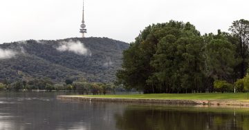
The National Capital Authority is letting the world know that they’ve decided Lake Burley Griffin is now safe to swim in, should you so choose.

The one exception is Weston Park East, which is often a bit of a debris trap as water flows through the lake.

Weston Park East is closed to recreation that involves whole-body water contact or submersion of the head. Examples include swimming, diving and windsurfing.

Lake Burley Griffin has been closed for the last fortnight as a result of sewage contamination.

Although bacteria has returned to a safe level in most areas of the lake, the National Capital Authority warns users of large objects or debris that may be partially or completely submerged.

The NCA’s now hard at work cleaning up the debris and ask if you see something to email natcap@natcap.gov.au or call 6271 2888.

(Or if it’s funny get a picture and send it in to images@the-riotact.com )

Join the conversation

5
All Comments
  • All Comments
  • Website Comments
LatestOldest

I lived her since 1991 and never seen the point of lake Burley Griffin or any of the lakes in Canberra as they are not usable by the general public. I have always thought they were storm water traps. I would definitely not eat any fish that came out of the lakes in Canberra. Why don’t they let power boats in that lakes to stir up the water and get some oxygen in the water

I saw a dead dog floating in it 🙁

I like the Westlake Esplanade idea – would be great if our fair city planners could open up something along the lines of boardwalks and the like so we could all stroll in that area, just like up near Reconciliation Place

Skidbladnir said :

If you’re wondering why:
Google Map of modern area
Map of where the river was and contours of the underwater area (complete with intended roads and the Arboretum-that-never-was.

The Lake builders for some reason widened the river channel there, while creating Spinnaker Island.

Damn good work, Skidbladnir! Thanks!

If you’re wondering why:
Google Map of modern area
Map of where the river was and contours of the underwater area (complete with intended roads and the Arboretum-that-never-was.

The Lake builders for some reason widened the river channel there, while creating Spinnaker Island.

Daily Digest

Want the best Canberra news delivered daily? Every day we package the most popular Riotact stories and send them straight to your inbox. Sign-up now for trusted local news that will never be behind a paywall.

By submitting your email address you are agreeing to Region Group's terms and conditions and privacy policy.