Update 3pm Tuesday
The ACT Government is advising motorists and other road users that Swamp Creek crossing on Fairlight Road is now closed due to flooding.
Orroral Road at the intersection with Boboyan Road has been reopened.
All unsealed reserve and forestry roads, such as fire trails and management roads, are now closed to the public due to expected high water levels across the region.
The closures include, but are not restricted to, the area around Murrumbidgee River and its tributaries, as well as the Cotter River and Molonglo River. Swamp Creek on Fairlight Road has also been closed.
Due to the predicted high water levels the following recreational areas are now also closed at:
- Uriarra (East, West and Swamp Creek)
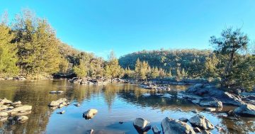
- Casuarina Sands
- Kambah Pool
- Pine Island
- Point Hut (East and West)
- Tharwa Bridge picnic area
- Tharwa Sandwash
- Angle Crossing.
It is also likely the Cotter Campground will be closed. An update will be provided as necessary. All walking trails to or from these recreational areas are also closed.
ACT State Emergency Service chief officer Conrad Barr has urged all Canberrans to continue to be vigilant and remain safe during the ongoing period of wet weather.
“There are number of road closures in place and it is important not to disregard the locked gates or temporary barriers preventing access.
“You may think you know a particular area or crossing, but it doesn’t take much water to make a difference and put you or loved ones in serious danger.
“Never enter or travel through floodwater, as the current can be very deceptive and you never know what has been washed away below what you can see. Even in a couple of centimetres of muddy water, you can’t tell if a part of the road has given way or if there are holes, boulders or logs that could catch your vehicle.
“Canberrans need to stay safe and out of flood water.”
Due to the wet weather, the following closures remain in place:
- Uriarra Crossing
- Point Hut Crossing
- Angle Crossing
- the unsealed section of Brindabella Road (except four wheel drive vehicles)
- Booroomba Rocks Road
- Orroral Ridge Road
- the unsealed section of Boboyan Road (except four wheel drive vehicles)
- Coppins Crossing
- Oaks Estate Crossing
- Sunshine Crossing
- London Bridge Road at the southern entrance to Googong Foreshores
- Googong Foreshores downstream picnic area (at the northern end)
- Googong Foreshores boat ramp (boating is currently not permitted on the dam).