2 September 2011

Three burn weekend

| johnboy
Join the conversation
3

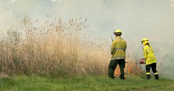
The ACT Rural Fire Service (ACTRFS) will conduct three hazard reduction burns this weekend in the ACT.

Tomorrow, Saturday 3 September, 2011, the ACTRFS Gungahlin and Southern Districts Brigades will conduct hazard reduction burns at the Gungahlin Eucalypt Plantation and at Castle Hill weather permitting.

The Gungahlin Eucalypt Plantation burn will commence from 2pm-5pm, north of the new suburb of Bonner.

Two heavy tankers, one medium unit, one light unit and 12 personnel will conduct the burn covering a total area of approx 10 hectares.

The ACT Handy Map grid reference for the Gungahlin burn is L8.

Also,tomorrow, the Southern Districts Brigade will assist a private landholder in the Castle Hill burn from 10.30am.

Two medium units, one light unit and 10 personnel will conduct the burn covering a total area of approx 10 hectares.

The ACT Handy Map grid reference for the Castle Hill burn is J16.

On Sunday 4 September, 2011, weather permitting, from 10am till 5pm, the ACTRFS Guises Creek Brigade will assist a private landholder with a hazard reduction burn on the property of “The Schools”, Monaro Highway, Royalla.

Two tankers, one light unit and 15 personnel will conduct the burn covering a total area of approx 10 hectares.

The ACT Handy Map grid reference for the burn is L16.

The ACT Handy Map can be found by clicking on the link on the Bushfires Home page of the ESA website, or on the inside back cover of the 2011/12 Canberra and region Yellow Pages phone directory.

The purpose of all three burns is to reduce a fire hazard with the removal of accumulated fuel.

[Courtesy ESA]

Join the conversation

3
All Comments
  • All Comments
  • Website Comments
LatestOldest

Oh and I forgot, that of course during an emergency that you can expect phones, power and internet links to be fully available……..
Link http://www.esa.act.gov.au/ESAWebsite/content_esa/fire_safety/act_handy_map/act_handy_map.html

Al, Most people have access to a phone book. Not everyone has the luxury of a computer at home or bandwidth to burn on Google maps. The maps are also on the back of the fire awareness stick on fridge thingy that the ESA gives away.

Gungahlin Al4:13 pm 02 Sep 11

Jeez a big fail to ESA for this. They could just embed a Google Maps link to each of the locations but that would be too easy…

Instead in a hyperlink-free zone, they refer in text to obscure non-standard grid references on a map, and describe where you should click on their website to find said map, only to find no such map available on that page, or go find a hard copy Yellow Pages – as if anyone keeps those these days!

“The ACT Handy Map grid reference for the Gungahlin burn is L8. The ACT Handy Map can be found by clicking on the link on the Bushfires Home page of the ESA website, or on the inside back cover of the 2011/12 Canberra and region Yellow Pages phone directory.”

Anyone else would post easy links, couple more clicks and I’ve cross-posted to the GCC Facebook page, and bingo a whole bunch more people know about it. Instead they make it bloody hard. Grrr

Daily Digest

Want the best Canberra news delivered daily? Every day we package the most popular Riotact stories and send them straight to your inbox. Sign-up now for trusted local news that will never be behind a paywall.

By submitting your email address you are agreeing to Region Group's terms and conditions and privacy policy.