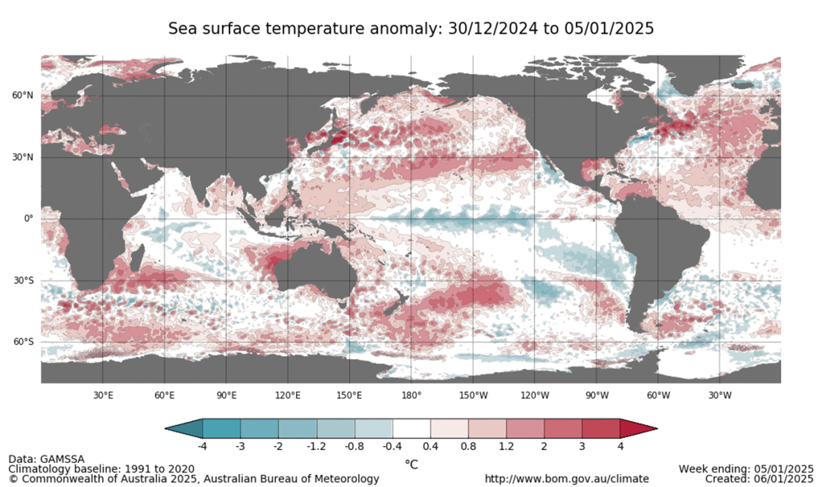
A chart from the first week of January showing cooler sea temperatures in the central and eastern Pacific, and warmer sea temperatures around the western Pacific and Australia’s north. Image: BOM.
Australian and global meteorological organisations are predicting a wet start to 2025 for eastern Australia, with what looks like the formation of a weak La Niña weather pattern in the Pacific Ocean.
A recent report by the Australian Bureau of Meteorology (BOM) says global sea temperatures remain substantially above average and that November 2024 saw the warmest average month of sea temperatures ever recorded.
It says these warmer ocean temperatures to Australia’s northwest and east are beginning to contribute to higher rainfall levels in Australia’s east.
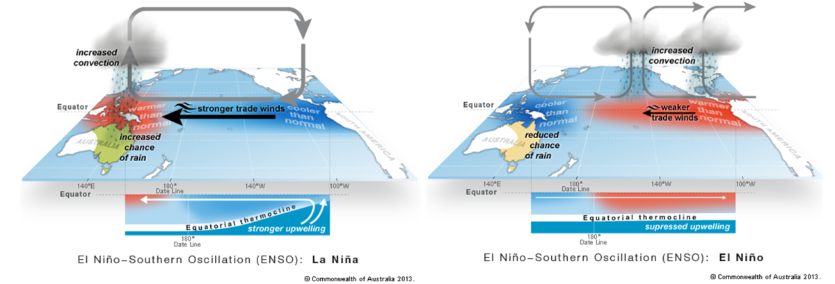
La Niña – Spanish for ‘girl child’ – refers to the cooling of sea temperatures in the central and eastern Pacific Ocean that can affect weather patterns right across the Pacific.
The US National Oceanic and Atmospheric Administration (NOAA) says La Niña events are characterised by stronger-than-usual trade winds that push more warm water toward Asia.
Off the west coast of the Americas, upwelling brings cold, nutrient-rich water to the surface. These cold waters push the jetstream further north, leading to dryer conditions in the southern US and wetter conditions in the US and Canadian northwest.
In the southern hemisphere and western Pacific, that warm water pushed west creates wetter conditions in Australia and along the east coast in particular. During prolonged or extreme La Niña events, we see major flood events like those seen in Victoria, NSW and Queensland from 2020 to 2022.
Conversely, droughts in Australia often coincide with El Niño – or ‘boy child’ – events, during which the waters of the central and eastern tropical Pacific Ocean are warmer, causing dryer conditions in the western Pacific.
Each of these events was previously mapped as having three to eight-year cycles, with neutral periods in between. However, climate change has meant that previously reliable weather models need to be reviewed.

Graphic depictions of La Niña and El Niño weather patterns. Image: BOM.
La Niñas usually start to form in Australia’s mid-to-late winter, peak in the spring, and then taper off through the summer. And while the BOM currently characterises this El Niño–Southern Oscillation (ENSO) cycle as being in the neutral range, it says atmospheric indices and trade winds have strengthened towards La Niña since November.
The BOM had previously forecast a La Niña event to form in autumn and winter 2024 but says it subsequently stalled. It says that for an event to become established, both atmospheric and oceanic indices would need to be sustained at La Niña levels for at least three months. If a La Niña event were to be declared, it would be the fourth such event since 2020.
It says the current indicators show that the trade winds are stronger than usual, the Southern Oscillation Index, which measures the intensity of these events, is above the La Niña threshold, and the tropical Pacific subsurface is cooler than normal.
The ABC reports that the BOM is predicting a swing to wetter-than-normal conditions for the next three months in NSW, the ACT and Queensland, while the highly regarded European Centre for Medium-Range Weather Forecasts (ECMWF) says there is a 90 per cent chance of above-median rainfall across Australia’s east coast as far south as Adelaide and Melbourne.
The World Meteorological Organization (WMO) is less ambitious in its prediction, saying there is a 60 per cent chance a La Niña may develop over the next three months, but says if it does it will be relatively weak and short-lived.
WMO Secretary-General Celeste Saulo says, “The year 2024 started out with El Niño and is on track to be the hottest on record. Even if a La Niña event does emerge, its short-term cooling impact will be insufficient to counterbalance the warming effect of record heat-trapping greenhouse gases in the atmosphere.
“Even in the absence of El Niño or La Niña conditions since May, we have witnessed an extraordinary series of extreme weather events, including record-breaking rainfall and flooding, which have unfortunately become the new norm in our changing climate.”
The WMO agrees with the BOM’s assessment that oceanic and atmospheric observations currently continue to reflect neutral conditions and that sea surface temperatures are slightly below average over much of the central to eastern Pacific.


