15 April 2008

Why no district signage for Gungahlin?

| nanzan
Join the conversation
46

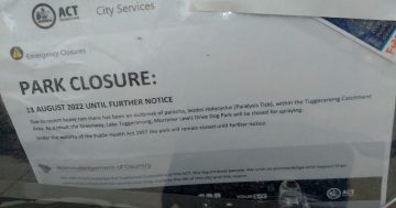
Can anyone out there explain why Gungahlin is the only district of Canberra that does not have district signs (to guide and welcome people into Gungahlin)? There are signs for the suburb of Gungahlin, but not for the district. All other districts (such as Tuggeranong, Weston Creek, Belconnen etc) have such signage at the entrances to the district, so why not Gungahlin?

Join the conversation

46
All Comments
  • All Comments
  • Website Comments
LatestOldest

Gung Al: I take Nurdurr daily to my place and have seen the earthworks started for a big roundabout at that extension into Crace. Will it follow the Gregory’s Street Directory planned route? Me thinks not. Why?

I mentioned a few weeks back what looked like an intersection on Gunghalin Drive from new ‘Franklin’ between Kosiosko and Wells Station at Mitchell. You thought not as simply not logical.

Drove past today and they have now pegged [with little purple flag things] the median strip opposite – right where I thought they were building that intersection. This would be the “logical” join-up with Nurdurr for Crace.

But not logical to put a another big slow down on Gunghalin Drive. Thousands more people and no more decent infrastucture. 🙁

But they have been pretty quiet about it.

Gungahlin Al3:05 pm 17 Apr 08

Forgot to mention – there was a speed camera half way down Northbourne inbound this morning too.
Can’t see it catching too many when no-one can physically do more than 40…

Gungahlin Al8:29 am 17 Apr 08

PS: thanks for the thoughts on GunSmoke. Latest is here for any who didn’t get it.

Gungahlin Al8:27 am 17 Apr 08

Thanks for the heads-up minime. Haven’t been down that way for a while. But will check out the issues you raise.

We have had some good news on Crace that Nurdurr Drv will definitely be extended to Gungahlin Drv. Palmerston residents have been concerned about the Crace traffic that will end up rat running through Kosciuzsko Ave. Just the timing that is in question – Andrew Barr is trying to get it brought forward, to his credit.

Related topic: thought I’d give Gungahlin Drive a run this morning at 7.45 as an alternative route to the city. Both southbound lanes chokko and only doing 60 to the Barton Hwy intersection, where most of the traffic (obviously better in the know than I) pelled off. Stayed at 60 to Ginninderra Drive intersection, then it was choked and down to maybe 20. I bailed and took Ginninderra – wanted to get here today. So am yet to experience the *wonders* of the full GDE in peak hour…

And Northbourne was about as bad as it has ever been. Mr Hargreaves, I believe it’s a case of “told you so.”

On the other hand, it was virtually empty northbound, so if we finally get some employment out our way, it will be a cruisey run for anyone commuting from further south.

Gunga Al: The magic goes on in the Gunghalin stuff-it-up section down at Stanhope’s. Have you seen the new intersection being built into the-coming-to-you suburb of Crace? It is on Gundaroo Drive! Yep, just east from the giant Barton Hwy roundabout that banks traffic back on Gundaroo for Kms already! One would think that planners would at least duplicate that 100 metres as well. Oh, and its on a bend. Just down from an existing intersection into that paddock. Yep again; there is already a road into the-up-and-coming slum of the future. Do appreciate the Gunsmoke, Al.

CanberraResident3:44 pm 16 Apr 08

TroyWilliams said :

Anyone else think that the Gunge looks rather a lot like a West Bank settlement without all the road blocks?

– Classic!

Ha! I said a similar thing on RiotACT about three weeks ago. It went something like “Gungahlin can be liked to the outskirts of Kabul”.

Glad I’m not the only who thinks so. And I live here! Oh dear. Needless to say, I really do enjoy my trips to Tuggers – the Brindabella mountains are gorgeous; beats the Gungahlin Desert anyday.

Jonathon Reynolds12:54 pm 16 Apr 08

@nanzan

Don’t hold your breath on the signage… this government assigns a higher priority dumping a heap of RSJ’s on the side of the road and calling it an art installation rather than concentrating on the essentials.

Gungahlin Al said :

Yes Jonathon is right – my bad. I live in Mullangarri. D’oh. Why they renamed it Barney I dunno. The area I was thinking about that is now Goorooyaroo Reserve was going to be part of a much larger Throsby that is currently on the plans.

Nanzan: just seizing the segue. The signage issue we sort of covered some time back on our website. I’m swayed by CR’s reasoning tho.

Oh – and on servos, 2 points:
1/ there are 5 actually – 2 in the town centre, i in Mitchell, 1 in Gold Creek, and the Shell next to EPIC (technically part of Gungahlin, being between the two highways).
2/ the Amaroo servo built by Renato Cervo was supposed to commence operation by 23 March or lose the DA. The word is that no petrol company will buy the joint because he built the main awning too low for trucks to get under…

Thanks Gungahlin Al for your comments re signage. Yes, I saw that story in The Chronicle and the GCC website about the tourist signage. Has it been changed yet?

However, I still think Gungahlin should have its own district signage at its perimeters. Belconnen has separate signage for both the suburb and the district, so there is a precedent. I have emailed TAMS about this so we’ll see what happens. All the other districts have signage so they will have to be erected for Gungahlin too, I imagine.

The real confusion currently arises when the district signs and the suburb signs are identical in design, size and shape. Seems to me that there should be some differentiation in the signage, especially in Belconnen and Gungahlin where there is that doubling up in nomenclature.

@Barney

they were giving out these mini yellow pages booklets at ainslie shops last week, about a5 size with street maps/directory in the front and an assortment of businesses in the back.
Pretty good to chuck in the car and replace that 10 year old street map, mind you the good old street map has all the essentials anyway, what’s a few missing roads/suburbs going to do to you.

Gungahlin Al11:30 pm 15 Apr 08

Yes Jonathon is right – my bad. I live in Mullangarri. D’oh. Why they renamed it Barney I dunno. The area I was thinking about that is now Goorooyaroo Reserve was going to be part of a much larger Throsby that is currently on the plans.

Nanzan: just seizing the segue. The signage issue we sort of covered some time back on our website. I’m swayed by CR’s reasoning tho.

Oh – and on servos, 2 points:
1/ there are 5 actually – 2 in the town centre, i in Mitchell, 1 in Gold Creek, and the Shell next to EPIC (technically part of Gungahlin, being between the two highways).
2/ the Amaroo servo built by Renato Cervo was supposed to commence operation by 23 March or lose the DA. The word is that no petrol company will buy the joint because he built the main awning too low for trucks to get under…

TroyWilliams10:36 pm 15 Apr 08

Anyone else think that the Gunge looks rather a lot like a West Bank settlement without all the road blocks?

– Classic!

Weston Creek is down to 2 servos… does this mean that they are they no longer a District? I thought that weston creek was just kinda a part of woden… Kinda like the Lanyon area is just part of Tugg…

Not quite sure I even know where it is, or where it goes (except it evidently goes to Gunghalin).

Actually, I think that it goes to Mitchell, then swings 90degrees to the west before finally going somewhere else.

There is also a confusing South Canberra sign, just as you get to Parliament House on Yamba Drive – basically just as you are leaving south Canberra.

Anyone else think that the Gunge looks rather a lot like a West Bank settlement without all the road blocks? All that barren area then bamm! a settlement

Still. Nobody has come to my rescue.

Meconium said :

I’m with CanberraResident – could be to avoid confusion. Belconnen has no suburb either does it? It’s Macquarie/Bruce afaik. Manuka is in Griffith, Jamison is in Macquarie, Tuggeranong is in Greenway, Woden is in Phillip.

As GnT said, Belconnen is the name of the central suburb of the district of Belconnen. Think about where Lake Ginninderra College, Belconnen Mall, and Emu Ridge estate are – this is all the suburb of Belconnen. I used to live there!

And yes, having a suburb and a district with the same name is confusing – but the powers that be were determined to repeat that Belconnen (so-good-they-named-it-twice) blunder with Gungahlin…and so it came to pass.

Emu Ridge, by the way, is an estate within the suburb of Belconnen; exactly like Swinger Hill in Phillip, and Gleneagles in Kambah, and Harcourt Hill in Nicholls.

Morgan said :

As a resident of the real part of Canberra, the Inner North, I must say there is no “Civic”, “City” or “Inner North” sign to designate our Town Centre.

Morgan, there are in fact quite nice new illuminated signs for “City Centre”, which replaced some of the large black and white ones. There are also some district signs for North Canberra, as there are for South Canberra. Some of the signage is almost historic, I might add; look at the “City Centre” one in Edinburgh Avenue opposite the swanky new NewActon complex.

Thanks for all that Gungahlin Al, that was very informative.

However, you didn’t mention anything about the lack of district signage for Gungahlin, which is the topic of this thread.

Regards.

sexynotsmart6:58 pm 15 Apr 08

It’s practically south Campbelltown anyway. So I guess there are signs to assist you leave, but not return. TAKE THE DAMN HINT! Especially if you have a tasteful 3 or 4 bedroom place in Nicholls, or overlooking the golf course.

(Sorry, there are no points for guessing what I’m in the market for.)

Gungahlin Al6:38 pm 15 Apr 08

Mullungarrie was on some of the older concept plan maps I was flicking through in some of GCC’s old records the other day, but I guess that was before they realised that the area and beyond to the north is one of the largest remaining grassy box woodlands around, and instead established the Goorooyaroo Nature Reserve.
No loos, but plenty of trees…

Troy’s fishing for a bite, so I’ll seize the opportunity to provide a snapshot of what we’ve been up to. 🙂

On the town centre Master Plan Review , ACTPLA reps and the transport plan consultants will be coming to the GCC meeting at Palmerston on Wednesday 14 May at the community centre Tiptree Crs (7.30pm). There has been plenty happening on that front and we’ve already been involved in some workshops. Key concerns we have been discussing revolve aroundthe stupid design of Flemington Road that currently directs all the through traffic right into the main street instead of around it. So we are trying to get this fixed, so the town centre becomes about destination traffic.

Ideally, Hibberson Street would (in my view anyway) be something like Childers St in the uni precinct – semi-pedestrianised, buses, deliveries, cars allowed but too slow to discourage through traffic, all while preserving some traffic so the shops maintain the casual surveillance that is lacking in malls.

But I guess the reason it is in the “planning stage” again is because we expressed concern that the current situation would not allow adequate employment and commercial expansion. Andrew Barr and Neil Savery took our concerns on board, and it is all being revisited.

On the college, the working group is to reconvene in a couple of weeks to look at the latest revision of the architects’ plans, and the library is an integral part of that. Those facilities are slated to open for the 2010 school year.

The aquatic centre master planning has been done. We’ve been emphasising the need for a 50/25/wader combination. The latest I saw seemed to have dropped the 25 but when I met with Andrew Barr a couple of weeks back I pointed out that a 25 is critical for all the learn-to-swim classes. Hopefully the budget will include initial funding to kick that project off. The “enclosed oval” next door has also had master planning well under way. Similar funding commitments will be looked for in the next budget (it being an election year…).

You can read about some of this in the latest edition of our newsletter, which goes to some 14,000 homes.

But yes – it has all been taking too long up until recently. Now everything is being accelerated in line with our requests, but it is almost too much for us to keep up with now, and we could sure use some extra people. If any RA readers who live out our way would like to get involved in achieving some of these sorts of hands-on outcomes, please drop me a line!

[off soapbox]

People know they’re in Gungahlin by virtue of all the McMansions, no need for a sign.

As a resident of the real part of Canberra, the Inner North, I must say there is no “Civic”, “City” or “Inner North” sign to designate our Town Centre.

Look on the bright side, at least Gungahlin’s on the Toilet Map……

toiletmap.gov.au lol!

Yeah no doubt, but I thought that people actually lived there, as it seems as such.

neanderthalsis4:17 pm 15 Apr 08

Mullangarrie must exist as it is listed on the Dept of Health and Ageings national public toilet map as having no toilets. So not a place you’d really want to visit incase you’re caught short.

http://www.toiletmap.gov.au/browse.aspx?type=area&id=3399ed58-1206-4e60-8257-aaeb3d01539e

Is it’s a sign?

Still no word on Mulanggarri?

TroyWilliams3:24 pm 15 Apr 08

Of course Gungahlin doesn’t have too many signs pointing to it. Non-locals would find the suburb, perhaps drive there out of curiosity and notice the lack of infrastructure. Pools that don’t exist, a town centre that seems to be perennially in the planning stage (they will get to it one day, I’m sure) and a school and a half. There is a police station but not too many police …

Once in Gungahlin you will find plenty of signs. A ‘future school site’ here, a ‘future library site’ there, etc, etc.

I’m sure GungahlinAl can update us where things are.

Growling Ferret3:17 pm 15 Apr 08

“Gungahlin needs to earn its stripes before being declared as a district of Canberra. Fer christs sakes, they’ve only got two petrol stations!!!”

Weston Creek is down to 2 servos… does this mean that they are they no longer a District?

I thought it was because nobody had anything nice to say about Gungahlin.

Kramer,
It’s got 4, if one counts the Mitchell and Federation Square ones. Plus the fifth “ghost” one in Amaroo.

CanberraResident said :

Ha! Time for an upgrade I think. $16.95 local servo. On second thoughts, it’s probably not worth the expense. Just wing it when next on the GDE …

errr, I haven’t been on the GDE yet, either. Not quite sure I even know where it is, or where it goes (except it evidently goes to Gunghalin). I think I might have seen a bit of it when trying to get to Calvary to see an ankle-cutter-upper, in 2006.

Snahons_scv6_berlina2:45 pm 15 Apr 08

Sheez, does it really matter ?

Belconnen does have a suburb called Belconnen, as well as it being the name of the wider area.

I thought they were called ‘towns’ not ‘districts’. Is there a formal name they’re supposed to be known as?

I’m with CanberraResident – could be to avoid confusion. Belconnen has no suburb either does it? It’s Macquarie/Bruce afaik. Manuka is in Griffith, Jamison is in Macquarie, Tuggeranong is in Greenway, Woden is in Phillip.

Does anybody actually live in Mulanggarri? I’ve never heard of that suburb before.

Gungahlin needs to earn its stripes before being declared as a district of Canberra. Fer christs sakes, they’ve only got two petrol stations!!!

…and my Canberra Street directory doesn’t show Gungahlin either!

b2 said :

Just pick up one of those free yellow pages mini directories they’ve been handing out at local supermarkets, it’s got a free map and everything.

What?

Just pick up one of those free yellow pages mini directories they’ve been handing out at local supermarkets, it’s got a free map and everything.

CanberraResident1:15 pm 15 Apr 08

ant said :

I can’t go to Gungahlin yet, as my canberra map doesn’t have it on.

Ha! Time for an upgrade I think. $16.95 local servo. On second thoughts, it’s probably not worth the expense. Just wing it when next on the GDE …

Because no-one outside Gungahlin gives a proverbial?

I can’t go to Gungahlin yet, as my canberra map doesn’t have it on.

CanberraResident11:28 am 15 Apr 08

I wonder … given there is actually a suburb called Gungahlin, as well as the district of Gungahlin, they are trying to avoid confusion. Tuggeranong has no suburb of the same name. Weston Creek is arguable. Woden has no suburb of same name. Maybe they’re just trying to avoid confusion with the actual suburb, or they’ve just plain forgotten. Just a hunch, not sure though.

neanderthalsis11:21 am 15 Apr 08

I was under the impression that Gunghalin was one of those magical and mythical towns that don’t really exist, like Atlantis and Perth. if it doesn’t exist, no need to signpost it.

Also, why is there a sign for Moncrieff on Mirrabei Dr. There’s nothing there, nothing been built or prepared to be built.

What I found really strange was the “Guide to Belconnen” on Gundaroo Dr, but I think that may have been removed now.

Daily Digest

Want the best Canberra news delivered daily? Every day we package the most popular Riotact stories and send them straight to your inbox. Sign-up now for trusted local news that will never be behind a paywall.

By submitting your email address you are agreeing to Region Group's terms and conditions and privacy policy.