4 June 2013

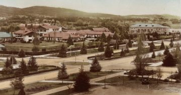
Canberra aerial photography from the 60's

| Barcham
Join the conversation
35

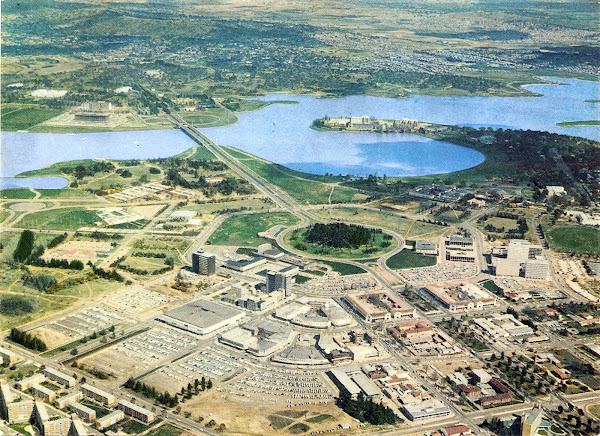
Canberra Aerial
High-Res Version

Rioter John sent us these scans in case anyone was interested.

Found an olde Canberra aerial postcard in a family collection. National Library construction indicates 1967-maybe 1968?

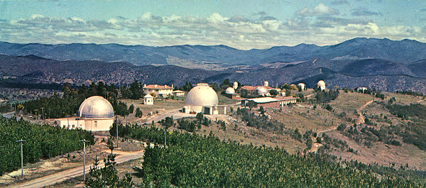
Also I have an old Mt Stromlo postcard for the same treatment if possible.

Thanks John!

Mt. Stromlo
High-Res Version

Join the conversation

35
All Comments
  • All Comments
  • Website Comments
LatestOldest

A news article in the 1965 Canberra Times suggested that old topographical maps show the area as Camp Hill or Kurrajong Hill. I guess if they are close together then the CT researcher misread the maps. Thanks johnboy.

GardeningGirl12:54 pm 05 Jun 13

CicsoKid said :

gooterz said :

Kurrajong Hill is visible in the background. There was no ‘capital hill’.

There was a Capital Hill, before that a Capitol Hill (spelling changed on some maps back in the 1930s), before that Kurrajong Hill or Camp Hill.

I remember asking my parents why Capital Hill was misspelled with an ‘o’.

Camp Hill and Capital Hill are different hills in roughtly the same place:

http://en.wikipedia.org/wiki/Capital_Hill,_Australian_Capital_Territory

p1 said :

Roundhead89 said :

That’s not Capital Hill, it is City Hill which is very much the same now as it was back then.

Unless Paul is referring to the hill on the other side of the lake round about where parliament house now sits?

Indeed. I was referring to the other hill.

Jack_Malarkey11:49 am 05 Jun 13

Wonderful photos. Brought back very happy memories of Canberra in the early 1960s. I left the place in 1974 at the age of 16 when my father took up a job in Melbourne but came back in 1985 as I missed the place so much. I originally came here in 1959 at the age of three months.

Canberra is a great place now but it was also a great place (of a different kind) when these photos were taken. Thanks so much for sharing.

gooterz said :

Kurrajong Hill is visible in the background. There was no ‘capital hill’.

There was a Capital Hill, before that a Capitol Hill (spelling changed on some maps back in the 1930s), before that Kurrajong Hill or Camp Hill.

I know this comment is pretty obvious, but its still amazing how decisions made in the mid 1960s about road layout or building locations still are of major importance today. Goes to show just how essential proper city planning is.

Mysteryman said :

Look at all the carparking!

What are those open spaces with cars in them?

Sigh ….parking

GardeningGirl10:44 pm 04 Jun 13

Gerry-Built said :

Fascinating – great share, John!

I have vague memories of School Holiday program at the YMCA in Glebe Park; I’ve wondered for years exactly where that was…

The one with the wavy roofline? It was on the corner of London Circuit and Constitution Avenue, sort of opposite the pool. There was a ten pin bowling alley beside it.

Fascinating – great share, John!

I have vague memories of School Holiday program at the YMCA in Glebe Park; I’ve wondered for years exactly where that was…

Ozhair said :

Roundhead, you do realise that Capital Hill is also visible in the photo…?

Kurrajong Hill is visible in the background. There was no ‘capital hill’.

Also the war memorial was going to be a casino.

Roundhead, you do realise that Capital Hill is also visible in the photo…?

the hill at the back of the shot is capital hill though… 🙂

Holden Caulfield5:20 pm 04 Jun 13

Pork Hunt said :

Wonder what those buildings in Commonwealth Park are?

I wondered that too. A plant nursery maybe?

I’m also liking the old skool “pchop” work on the lake as well, haha.

Holden Caulfield5:19 pm 04 Jun 13

Roundhead89 said :

That’s not Capital Hill, it is City Hill which is very much the same now as it was back then.

It’s Capital Hill in the background.

Holden Caulfield said :

Pics not working for me and only the second high-res link works too. 🙁

Limit of referrals from a site has been reached. Just copy and past the link url into browser and it should be fine.

GardeningGirl said :

That is so great! Thanks for sharing!

and from me as well.

Pork Hunt said :

Wonder what those buildings in Commonwealth Park are?

In the far right corner is the church land, controversially given the church for a public cathedral and public use, but in reality used as a private residence. There’s a lot of politics going on with that even now.

To the left of that, is Mulwala Hostel, it would have been demolished soon after these pics were taken.

Roundhead89 said :

Paul0075 said :

Beautiful photos. And nice to finally see a colour shot of Capital Hill before parliament house ended up there. I grew up coming to Canberra regularly from Sydney as a kid, but we never ventured over the lake most of the time as our family friends lived in Watson and their family lived in Dickson and Braddon.

That’s not Capital Hill, it is City Hill which is very much the same now as it was back then.

Unless Paul is referring to the hill on the other side of the lake round about where parliament house now sits?

Paul0075 said :

Beautiful photos. And nice to finally see a colour shot of Capital Hill before parliament house ended up there. I grew up coming to Canberra regularly from Sydney as a kid, but we never ventured over the lake most of the time as our family friends lived in Watson and their family lived in Dickson and Braddon.

That’s not Capital Hill, it is City Hill which is very much the same now as it was back then.

Wonder what those buildings in Commonwealth Park are?

Holden Caulfield3:07 pm 04 Jun 13

johnboy said :

problem apparently fixed for now.

Thanks to you both.

Awesome pics! 8)

Thanks for sharing, I love these kind of old images.

problem apparently fixed for now.

Google decided that I was out of bandwidth, should hopefully be fixed now. I need to stop hosting so many photos.

Solidarity said :

I wish I could spend a day in 60’s Canberra….

If Tony Abbott wins the election you may very well be able to spend time in an interpretation of the 1960’s!

Beautiful photos. And nice to finally see a colour shot of Capital Hill before parliament house ended up there. I grew up coming to Canberra regularly from Sydney as a kid, but we never ventured over the lake most of the time as our family friends lived in Watson and their family lived in Dickson and Braddon.

I’m getting an error from google. “Rate limit error”. Is it just me or is this picture so good it broke the interwebz?

Just Barcham’s bit. should have a fix soon.

Holden Caulfield12:06 pm 04 Jun 13

Pics not working for me and only the second high-res link works too. 🙁

I wish I could spend a day in 60’s Canberra. Just stroll around, looking at stuff…

It looks like a really ugly model of the city. Dis-Craceful, even. Trees make it look so much better.

GardeningGirl11:38 am 04 Jun 13

That is so great! Thanks for sharing!

Look at all the carparking!

Yep, that is where the City to the Lake project will be focussing, from Commonwealth Avenue round West Basin. You can really notice how open it is without the barrier of Parkes Way. It will be nice to be able to stroll down to the lake without crossing six lanes of Canberras finest.

Daily Digest

Want the best Canberra news delivered daily? Every day we package the most popular Riotact stories and send them straight to your inbox. Sign-up now for trusted local news that will never be behind a paywall.

By submitting your email address you are agreeing to Region Group's terms and conditions and privacy policy.