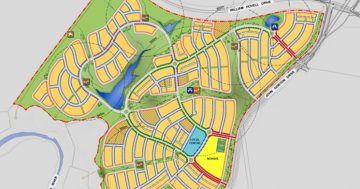
The interactive map of ACT Primary Schools has been updated to reflect the final decisions of the Stanhope Government. In short, Mt Rogers, Giralang, Isabella Plains and Gilmore are now classified as remaining open.
The proposed P-10 school on the Kambah High site (due to open in 2011 apparently) has been added to the map. It is not clear why they have decided to build a P-10 school right next to Urambi Primary School.
The lack of coverage in Weston is now a reality.
Chifley is badly affected as well. If you look at the map it seems well covered, but sending a child across the Tuggeranong Parkway to Arawang (in Weston Creek) is not viable, nor is it desirable to navigate through Phillip to Mawson Primary. If the circles for both of these schools are turned off (by clicking on the blue dot representing the school) then it is only the circle from Lyons that covers Chifley at all. Lyons is going to become a P-2 school. If the Lyons circle is turned off, the result is the coverage for kids from year 3 to year 6, i.e. none. An amalgamation of Lyons and Melrose on the Melrose (Chifley) site would have resulted in a more equitable distribution of schools.


