The ESA are warning that they’re going to be doing a burn around Narrabundah over the weekend:
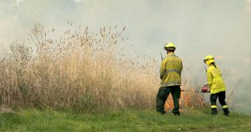
2:50pm Friday 24 September 2010 – Hazard reduction burn in Narrabundah on Sunday The ACT Rural Fire Service will be conducting a small hazard reduction burn at Narrabundah on Sunday 26 September 2010.
The burn on Jerrabomberra Avenue, between Narrabundah Lane and the Monaro Highway, is scheduled to commence at 11:30am.
Volunteer crews from Jerrabomberra, Guises Creek and Rivers Brigades will use the day to reduce half a hectare of grass fuel in the suburb and also to assess a number of new ACT RFS members.
The ACT Handy Map grid reference point for the burn is L13.
The ACT Handy Map can be found on the inside back cover of the current Yellow Pages Canberra and region phone directory or by clicking on the link below.
act handy map.pdf