The ABC reports that Giralang kids won’t be able to walk to school next year if the local Primary school is closed.
The Canberra Times covered the story as well, but it isn’t online. They did get a quote from Andrew Barr saying he had seen their map and thought they should include it in their submission.
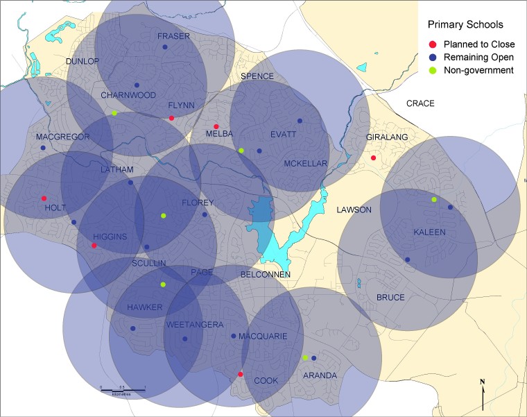
The map was reproduced by the Times, but exclusive to The RiotACT, here it is:

The schools planned to remain open are indicated by blue dots with a translucent blue circle of 1.6km radius overlayed. This represents a “walking circle”, and was the distance criteria chosen by a previous Government when proposing school amalgamations in the late 1980s. This represents the outer limit of “walkability” for most Primary aged children. Closing schools are represented by red dots and don’t have a walking circle.
The topography makes it even worse than it looks on the picture. There is a significant ridge between Giralang and Kaleen which prevents easy access to Kaleen Primary, and there are two major roads to cross (Chuculba Crescent and Maribyrnong Avenue).
The access to Evatt Primary is restricted because the western edge of Giralang is bounded by a stream and William Slim Drive. All foot traffic to Evatt has to go via the underpass near the roundabout where William Slim Drive and Owen Dixon Drive intersect.
All this adds up to kids not being able to walk to school. A real kick in the teeth as Giralang Primary has the highest walk to school rate in the ACT.
Update: The map has been updated with non-government Primary schools added (no walking circles for these schools though)


