Hi there Rioters,
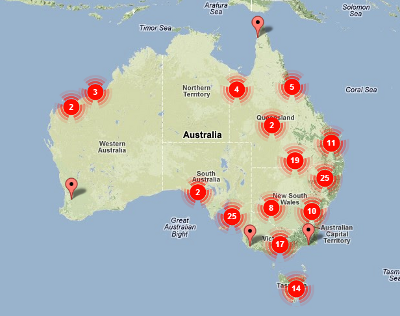
Given the current fire dangers affecting our region I thought people might be interested in this site I just came across. Dubbed ‘Australian Bushfire Map’ it appears to aggregate information from various state and rural fire services. The value is that you don’t have to navigate between the various state based sites individually – it provides a nation-wide overview.
Given this site isn’t the actual source of truth, you might still want to refer back to the local authorities themselves to confirm any information you are interested in, i.e. ACT Emergency Services and NSW Rural Fire Service.
It’s by a group/person calling themselves the Unorthodox Engineers.