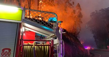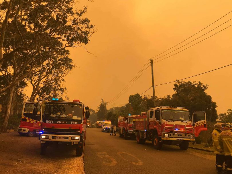
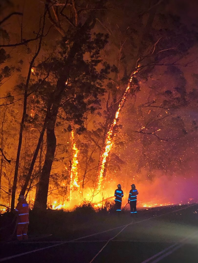
RFS and Fire and Rescue crew at Bawley Point yesterday, 5 December. Photo: Queanbeyan Fire and Rescue.
Update 5:00 pm, Friday 6 December
Community Briefing at Mackay Park Function Centre in Batemans Bay
After an intense week of fires, hundreds packed in to the Mackay Park Function Centre in Batemans Bay for a Community Briefing, with a sigh of relief as rain started to fall.
Posted by Breaking247 on Thursday, December 5, 2019
Update 10:00 am, Friday 6 December
Overnight, the Currowan fire impacted on the village of Bawley Point which had been surrounded by fire fronts to the north and south. During the height of activity, fire crews worked desperately to save houses and protect properties in the area.
The NSW Rural Fire Service today said, “A number of buildings have been destroyed in the area today. Building Impact Assessment teams will inspect the area when it is safe to do so.”
This morning, the fire has been downgraded from ’emergency’ to ‘watch and act’.
The latest from the NSW RFS is that the fire has spread quickly towards Bawley Point and Lake Tabourie.
The fire is now burning north of Lake Tabourie, and west of the Princes Highway.
The fire continues to be active in the areas of Kioloa, Pretty Beach, Pebbly Beach, Depot Beach and Durras North.
The Princes Highway is closed between Burrill Lake and the Kings Highway turnoff.
Fire has also progressed through the Budawang National Park and is currently very visible from areas around Mongarlowe and Braidwood.
A GoFundMe fundraiser for the Bawley Point Kioloa Bushfire Appeal has already raised more than $31,000.
Community meetings will be held today at 4:00 pm at both the Ulladulla Civic Centre in Ulladulla and at the Mackay Park in Batemans Bay.

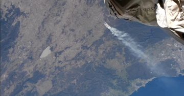
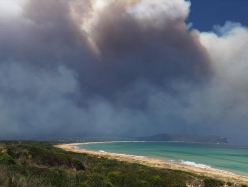
The Currowan and North Black Range Palerang fire grounds as of 10:00 am on Friday, 6 December. Photo: NSW RFS website
Update 6:00 pm, Thursday 5 December

The Currowan fire burning this afternoon at the lake at South Durras. Photo: South Durras Shop
The Currowan fire continues to move south while being pushed by strong and gusty winds. The town of Bawley Point has been impacted, with firefighters working to save houses in the area.
For people at Kioloa, Bawley Point, Pretty Beach, Pebbly Beach, Depot Beach and Durras North area and Termeil and Flat Rock area, the advice it is too late to leave.
RFS public liaison officer Brad Stewart said, “Monitor conditions around you, as there may be small areas of active fire burning for some time. Be aware of the dangers of trees and branches falling”.
Further south at South Durras, North Batemans Bay, Long Beach, Surfside, Maloneys Beach and Nelligen, residents have been told to leave now towards Batemans Bay if safe to do so.
The South Durras shop is reporting that the southerly hit at about 5:00 pm and saved the area. Spot fires were reported near the Lakesea Caravan Park and in the dunes at the entrance in a southerly direction but was all clear for now.
The NSW Rural Fire Service says the safest option is to leave early.
“Decide now what you will do if you’re threatened by the fire. Only stay if you and your property are well prepared. Stay up to date and be ready to take action,” Mr Stewart said.
The Princes Highway remains closed between Burrill Lake and the Kings Highway turnoff. For information on road closures, check Live Traffic NSW. Roads may be closed without warning.
Evacuation centres have been set up at:
- Ulladulla Civic Centre – 81B Princes Highway, Ulladulla.
- Mackay Park Function Centre – Corner of Beach Road and Princes Highway, Batemans Bay.
- Braidwood National Theatre Community Centre – 100 Wallace Street, Braidwood.
Posted by The RiotACT on Wednesday, December 4, 2019
Update 4:00 pm, Thursday 5 December
The Currowan fire has returned to an emergency level warning, with residents in the Lake Tabourie area warned to seek shelter as the fire approaches.
The NSW Rural Fire Service said the fire is spreading quickly through the Meroo National Park towards Lake Tabourie.
“If you are in the area of Lake Tabourie including areas to the west of Woodburn Rd, shelter as the fire approaches. Protect yourself from the heat of the fire,” the RFS said.
There are unconfirmed reports of the fire having crossed the south side of Lake Durras. “If you are at South Durras get ready to defend now,” the Durras Community Association said via Facebook.
For people in the Kioloa, Bawley Point, Pretty Beach, Pebbly Beach, Depot Beach and Durras North areas, it is too late to leave.
The strong winds forecast today have also the spread of the Currowan fire in a southerly direction.
The gusty north-westerly winds have blown the main fire front towards Nelligen and has joined a previously smaller fire north of Nelligen at Shallow Crossing.
NSW Rural Fire Service public liaison officer Brad Stewart told urges people to stay informed of the conditions.
Along the coast, wind gusts are reaching up to 60 km/h, while further west over the ranges and closer to Braidwood, the wind gusts are up to 75 km/h. The relative humidity is low at around 8 to 10 per cent on the Currawon fire ground, but that’s expected to improve tomorrow after a southerly change arrives in the early evening.
“That will drop temperatures and increase humidity to as much as 40 per cent overnight and tomorrow. The onshore winds will persist through the night.
“After the southerly comes through, we’ll see winds stay mostly easterly across the fire ground so the temperatures will still be warm but not as hot as today,” a BOM spokesman said.
The latest advice from the NSW RFS is that the fire continues to grow in the south towards Nelligen. The fire also continues to grow in the west towards Mongarlowe.
The fire is also moving in an easterly direction towards Termeil and Bawley Point.
The fire has impacted on areas around East Lynne and is expected to reach Lake Tabourie this afternoon.
The fire continues to be active in the areas of Kioloa, Pretty Beach, Pebbly Beach, Depot Beach and Durras North.
Firefighters are working to protect homes in all of the above areas.
The Princes Highway is closed between Burrill Lake and the Kings Highway turnoff. The Kings Highway is closed between Columbo Rd and Mayfield Rd either side of Braidwood due to increased fire activity of the fire near Braidwood.
The video below shows 21 fire management personnel from Canada who landed in Sydney this morning to support the firefighting effort.
A warm Aussie welcome to 21 fire management personnel from Canada who have landed in Sydney this morning to support the firefighting effort. ?? ??
Posted by NSW Rural Fire Service on Wednesday, December 4, 2019
Update 10:00 am, Thursday 5 December

The Currowan fire spills into the ocean at the north end of Depot Beach on Tuesday night. No houses have been reported as being burned in the area. Photo: Josh Burkinshaw Images
Residents of Long Beach and Maloneys Beach, north of Batemans Bay, are prepared as a day of severe fire conditions loom.
There has been further progress in the movement of the Currowan fire overnight as it continues to spread towards the coast in the areas of Kioloa, Pretty Beach, Pebbly Beach, Depot Beach and Durras North.
People in Long Beach and Maloneys Beach areas, to the north of Batemans Bay, were issued with warnings yesterday that there is nowhere safe if they decided to stay.
Currowan Fire Deputy Incident Controller Ken Hall had a clear message for residents of Long Beach, Maloneys Beach and North Batemans Bay. “Leave by 9:00 am tomorrow [Thursday]. Be prepared to be away for a week. If it [the fire] hits Cullendulla it’ll be going in that North Batemans Bay area about the same time, so leave tomorrow morning.”
Today’s forecast from the Bureau of Meteorology is for a strong wind warning for coastal areas near Batemans Bay. A severe fire danger warning and total fire ban have also been issued by the Rural Fire Service.
North-westerly winds are expected to pick up in the afternoon and are forecast to be up to 70km/h.
A NSW Rural Fire Service spokesperson said, “We’re going to see strong, gusting winds with increased temperatures and a severe fire danger rating and total fire ban in the area”.
Long Beach resident Mark Walker told Region Media the winds are currently light from the north-west. He said smoke in the area was thick early this morning but is clearing with the westerly breeze. “Everyone here has filled wheelie bins and buckets all around their houses and there are bins out indicating whether people have stayed or not,” Mr Walker said.
The latest RFS update says:
- Firefighters are working to protect homes.
- The fire is also moving in an easterly direction towards Termeil and Bawley Point.
- The fire is also impacting on areas around East Lynne.
Batemans Bay photographer Josh Burkinshaw also gave us permission to use these images of the fire spilling into the ocean. They were taken at the north end of Depot Beach on Tuesday night (3 December). Josh said no houses had been burned.
“These photos might be a bit confronting,” said Josh. “But I think they need to be shown and show the pure devastation of the bushlands here on the south coast.”
Further updates will be provided if the situation changes.
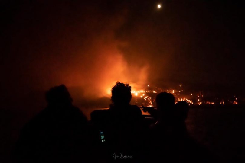
An image of the fire spilling into the ocean at Depot Beach on Tuesday night. Photo: Josh Burkinshaw Images
Update 1:00 pm, Wednesday 4 December

The Currowan fire as seen at Batemans Bay on Tuesday. Photo: Josh Burkinshaw Images.
“Everyone thinks we’ll have water, everyone thinks we’ll have electricity – but they can all be impacted by the fire. Around my house, I’ll be filling wheelie bins and buckets with water. Utilise what you’ve got, use your bathtub – anything you can put water in that’s what you need to be doing now.”
Deputy RFS incident controller Ken Hall’s strongly worded advice to Long Beach residents at a meeting mid-morning demonstrates with vivid clarity how urgent the Currowan fire situation remains for South Coast residents as the blaze moves increasingly towards coastal settlements.
The fire has now consumed more than 47,000 hectares and remains uncontrolled, oscillating with the winds and relative humidity levels.
The fire has now reached the coast at multiple points. As a smaller fire burns at Nelligen and firefighters face choppy gusting winds from both directions, the current fear is that the main blaze may burn back west and south, potentially around the edge of Batemans Bay and towards Mogo.
“You should be out of here by 9 tomorrow,” Mr Hall told Long Beach locals.
Long Beach locals have been told to fill their bathtubs, buckets and wheelie bins with water as the Currowan fire hits multiple communities along the coast. Gusting winds and rising temperatures are expected to make tomorrow particularly difficult.Latest update: http://ow.ly/QtAm50xq7Zq
Posted by The RiotACT on Tuesday, December 3, 2019
Locals are reporting periods of intense smoke and at least four structures including one home near the Clyde River have been destroyed in the blaze. Residents have been urged to enact their fire plans and to leave early to avoid barrow winding coastal access roads.
At East Lynne, firefighters rallied last night to save the general store on the Princes Highway.
The RFS says that the fire continues to spread towards Kioloa, Pretty Beach, Pebbly Beach, Depot Beach and Durras North and is also moving in an easterly direction towards Termeil and Bawley Point and impacting areas around East Lynne.
We’re at Termeil Creek south of Lake Tabourie #currowanfire #NSWRFS #NSWbushfires pic.twitter.com/S0RROvpTN2
— John Hanscombe (@JohnHanscombe) December 4, 2019
The fire has spotted in Meroo National Park, to the east of the Princes Highway, south of Termeil Creek and north of Bawley Point Road.
One of the complexities in this battle is the changing weather conditions, partly the fire is located in an area where winds converge. Coastal areas are already experiencing an easterly and the BOM says those winds are now also entering the fire ground.
Winds will drop overnight, tending nor-easterly, but pick up tomorrow when a strong gusty westerly will come over the ranges. There’s a possible southerly with late showers predicted for tomorrow evening, but it’s unlikely to make a significant difference to the situation.
The BOM says they’re anticipating temperatures inland in the low 30s, while on the coast they’ll reach around 28 degrees.
The Princes Highway is closed between Burrill Lake and the Kings Highway turnoff. Check Live Traffic NSW for updates.
Update 7 am, Wednesday 4 December

The Currowan Fire burning north of Batemans Bay covers almost 40,000 hectares, 7 am, Dec 4. Photo: NSW RFS.
What damage did the flames of last night do? It’s a question many in the southern Shoalhaven and northern Euorbodalla are waking up with most mornings as the Currowan Fire advances on their community.
Speaking with Region Media, James Morris from the NSW Rural Fire Service says three structures have been lost to the fire. “The structures are spread through the fire ground and I believe they are west of the highway. We don’t know what sort of structures they are yet, fire impact assessment teams are on the fire ground but it’s very difficult to get a clearer picture at this stage.”
What is clear is that the fire has devastated a large area of bushland – over 39,000 hectares, and late yesterday flames burnt all the way to the coast.
“Yesterday’s fire conditions weren’t meant to be that bad, today we will sit tight and hope for a break.”
Winds today will have a southerly influence and aren’t forecast to blow with the intensity of recent experience, but the forecast remains dynamic.
Crews will continue property protection between Kiola and North Durras, with the RFS mindful of trying to reopen the Princes Highway.
“But there are a lot of dangerous trees and still a lot of fire still burning on both sides of the highway,” Mr Morris says.
Easing conditions in the early hours of this morning saw the alert level downgraded to ‘Watch and Act’ but the fire is still considered as ‘out of control’.
Currowan Fire snapshot:
- The fire continues to spread quickly towards the coast in the areas of Kioloa, Pretty Beach, Pebbly Beach, Depot Beach and Durras North.
- The fire is also moving in an easterly direction towards Termeil and Bawley Point
- The fire is also impacting on areas around East Lynne
- The fire has spotted in Meroo National Park, to the east of the Princes Highway, south of Termeil Creek and north of Bawley Point Road.
- The fire is highly visible from areas including Lake Tabourie.
- The Princes Highway is closed between Burrill Lake and the Kings Highway turnoff.
- Kioloa, Bawley Point, Pretty Beach, Pebbly Beach, Depot Beach and Durras North area – seek shelter as the fire approaches. Protect yourself from the heat of the fire. It is too late to leave.
- Termeil and Flat Rock area – seek shelter as the fire approaches. Protect yourself from the heat of the fire. It is too late to leave.
- South Durras area – leave now towards Batemans Bay if safe to do so.
- Areas west of the Princes Highway between Termeil and East Lynne – monitor conditions. Take advice from firefighters in the area and follow your bush fire survival plan.
South Coast Police District Commander, Superintendent Greg Moore has acknowledged the ongoing cooperation and understanding of the local community during these challenging times.
“It’s important that the community continues to comply with the directions from the Emergency Services and maintain an awareness of the present conditions and notifications,” Superintendent Moore says.
“The hard work of our Emergency Services and the cooperation from members of the community to this point, has minimised the risk to safety and property damage.”
To stay up to date with all NSW bush fires check the NSW RFS website, listen to your local radio station, or call the NSW RFS Bush Fire Information Line on 1800 679 737.
For information on road closures, check Live Traffic NSW.
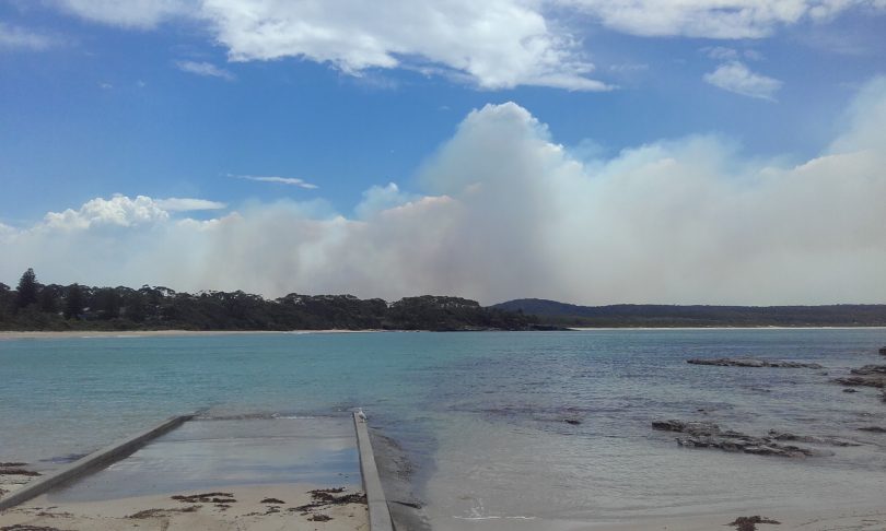
The Currowan fire as seen from South Durras, looking north on Tuesday. Photo: Simon Kringas via Facebook.
Update 7:30 pm, Tuesday 3 December
The Currowan fire is reaching a critical point as the blaze hits the coast in several locations and there is serious concern for properties between the Princes Highway and the ocean. Firefighters and aircraft are working to protect homes.
The fire is now spreading quickly towards the coast in the area of Kioloa, Pretty Beach, Pebbly Beach, Depot Beach and Durras North.
The RFS says that the fire continues to move in an easterly direction around Termeil and is also impacting on areas around East Lynne. There has been some spotting in Meroo National Park, to the east of the Princes Highway and North of Bawley Point Road.
Reports from the fire front say that conditions are extremely windy and there is a strong smoke haze impacting visibility and causing problems for fire crews. The rough and heavily timbered terrain is also making it difficult to assess exactly where the fast-moving fire front is.
These are the conditions facing firefighters and residents at the Currowan bush fire north of Batemans Bay. The fire has reached the coast in some areas. Difficult conditions, with firefighters and aircraft working to protect homes where possible. #nswrfs #nswfires pic.twitter.com/MzYH3rZDUn
— NSW RFS (@NSWRFS) December 3, 2019
The Princes Highway closure now extends between Batemans Bay and Ulladulla. The evacuation warnings below remain current and residents in the direct line of fire activity should shelter in place. Leaving late may risk lives.
Kiola Beach. Photo: Jess McAlpine.
The evacuation centre in Batemans Bay has now moved to the Mackay Park Function Centre on the corner of Beach Road and Princes Highway. In Ulladulla, the Civic Centre remains open.
The Bureau of Meteorology says that overnight, they are expecting westerly winds sitting on 25 km/h with gusts to 40 km/h. Those winds will persist for the early evening then ease off around midnight. The Bureau expects conditions tomorrow during the day to be difficult because western parts of the fire ground are likely to experience westerly winds at 30 – 40 km/h.
“It’s possible that some easterly winds will also develop but it’s not clear where the convergent boundary will be”, a spokesman said.
Temperatures tomorrow will rise to around 28 degrees on the fireground closest to the coast and 24 in higher locations, but the Bureau is expecting warmer and windier conditions on Thursday. Relative humidity this evening is around 50 per cent, but by mid-afternoon tomorrow that will drop to 20 per cent, and to just 15 per cent by Thursday.
“Weather-wise, Thursday looks like a day of elevated danger”, the spokesman said.
To stay up to date with all NSW bush fires check the NSW RFS website, listen to your local radio station, or call the NSW RFS Bush Fire Information Line on 1800 679 737.
For information on road closures, check Live Traffic NSW.
Update 5:00 pm, Tuesday, 3 December
The Currowan Fire burning between Batemans Bay and Ulladulla has again been elevated to the ‘Emergency Alert Level’ as it burns in an east and north-easterly direction towards the area of Termeil, Bawley Point and Pebbly Beach.
The NSW Rural Fire Service says the fire has now reached the coastline in some areas.
NSW Rural Fire Service spokesman Ben Shephard told Region Media the fire has run in a number of different fingers across the Princess Highway and is likely to reach the coast just north of Pebbly Beach.
“On the northern side of the fire, it’s in the area of Termeil and on the southern side of the fire, it’s in the area of East Lynne,” Mr Shephard said.
“The fire is burning towards the coast and is likely to impact on the areas of Depot Beach, Pretty Beach, Kioloa and potentially all the way up to Bawley Point.
“The fire has run off in a number of different fingers across the [Princess] Highway and is likely to reach the coast just north of Pebbly Beach.”
Mr Shephard said wind continues to blow in a westerly direction and is expected to keeping blowing from that direction for the next couple of days.
Mr Shephard said crews are actively fighting the fire at Kioloa. Police are also door-knocking in Maloneys Beach and advising people to leave.
The Currowan fire is again at an emergency level, crossing the Princes Highway in multiple places and burning in rough terrain. It remains an urgent and uncontrolled situation along the coast, and residents around Termeil and Flat Rock should now be seeking shelter as strong westerlies push the blaze towards the coast.Latest update: http://ow.ly/QtAm50xq7Zq
Posted by The RiotACT on Monday, December 2, 2019
Residents in the Termeil and Flat Rock areas are being advised to seek shelter as the fire approaches. The advice from RFS is to protect yourself from the heat of the fire because it is too late to leave.
The southern edge of the fire has been burning towards East Lynne and Benandarah. It has crossed the Princes Highway and is burning to the north of, and adjacent to, Mt Agony Road.
The Princes Highway remains closed between Burrill Lake and the Kings Highway turnoff.
Residents in areas between Bawley Point and North Durras, including Kioloa, Depot Beach, Pebbly Beach and Pretty Beach should also monitor conditions. Take advice from firefighters in the area and follow your bush fire survival plan.
The same advice goes for people in Durras Lake, Durras, Maloneys Beach and Long Beach area. But if you’re at South Durras, leave now towards Batemans Bay if it is safe to do so.
One of the key factors is the state of the roads as the fire crosses the Princes Highway in multiple places. On narrow winding coast roads, people who leave it too late may not get out at all. Falling trees are a significant risk on roads in these drought-affected conditions.
Evacuation centres are operating at the Ulladulla Civic Centre and at the Mackay Park Function Centre at Batemans Bay.
People are encouraged to register online at Register Find Reunite, a Red Cross run website that helps people keep track of where everyone is in an emergency. Register before you go to the evacuation centres.
Much of the focus in this rough, wooded terrain has been in defending properties and crews are working in and around Depot Beach and North Durras. Over the last 24 hours, crews have been actively defending properties in the Bundle Hill area and they are also working in Kioloa.
Strong westerly winds are forecast to continue today and push the fire predominately in an easterly direction.
Volunteer fire controller Ken Hall, a man with decades of experience on the ground, told Region Media yesterday that “it’s hard for people to get their heads around how bad this is – these fires won’t go out”.
Strong westerlies continue to cause problems for firefighters battling the Palerang Blaze. It remains at a watch and act level but is increasingly active burning west of Braidwood around Forbes Creek and the Cooma Rd.
To stay up to date with all NSW bush fires check the NSW RFS website, listen to your local radio station, or call the NSW RFS Bush Fire Information Line on 1800 679 737.
For information on road closures, check Live Traffic NSW.

Update 10:55 am, Tuesday 3 December
A life at the edge of crisis is becoming the norm for those living with two vast bushfires burning in the southern Shoalhaven and in the Queanbeyan-Palerang Shire.
The Currowan Fire burning between Batemans Bay and Ulladulla burnt long and hard into the night. After two days at the ‘Emergency Alert Level’ the NSW Rural Fire Service downgraded the situation to ‘Watch and Act’ at around 2 am this morning.
The fire has burnt close to 25,000 hectares to date and is not yet under control. Reports suggest that one house on the Clyde River, as well as other structures, have been lost to the flames of yesterday afternoon.
Speaking to residents of Long Beach, north of Batemans Bay yesterday, Rural Fire Service Deputy Incident Controller Ken Hall said a soaking of rain is the only thing that will extinguish the flames.
“We can’t stop this fire. It is so dry out in the bush, it will keep jumping over our control lines,” Mr Hall said.
Right now the fire is burning in a east and north-easterly direction, towards the area of Termeil, Bawley Point and Pebble Beach.
Social media footage of RFS crews keeping flames from the well known East Lynne Store overnight gives a sense of the volatile situation volunteers are facing.
Posted by Sonny Black on Monday, December 2, 2019
The southern edge of the fire is burning towards East Lynne and Benandarah. Crews have been actively defending properties in the Bundle Hill area and are in the vicinity of Kioloa to provide property protection if required.
The fire crossed the Princes Highway in a number of locations north of East Lynne and south of Termeil overnight.
The highway remains closed between Turmeil and the Kings Highway turnoff and is expected to remain closed for some time with authorities warning the fire is likely to cross the highway again in the coming days.
Today strong westerly winds are forecast to continue, pushing the fire predominately in an easterly direction.
Residents west of the Princes Highway between Termeil and East Lynne are advised to take advice from firefighters in the area and follow your bush fire survival plan.
Areas between Bawley Point and North Durras, including Kioloa, Depot Beach, Pebbly Beach and Pretty Beach, should continue to monitor conditions. Take advice from firefighters in the area and follow your bush fire survival plan.
For those in the South Durras area, RFS advice is to leave now towards Batemans Bay if it is safe to do so. Those still in the Termeil area are advised to leave now towards Ulladulla if its safe.
Evacuation Centres are operating at the Ulladulla Civic Centre and at the Hanging Rock Sports Club Function Centre at Batemans Bay. People are encouraged to register online at Register Find Reunite before attending evacuation centres.
National Parks and Wildlife Service has closed campgrounds in Murramarang National Park and all State Forests on the South Coast are now closed to the public until further notice due.
“There are many large dangerous fires moving across the landscape and we expect the high fire danger to continue for the foreseeable future,” NSW Forestry Corporation, Forest Stewardship Senior Manager, Kathy Lyons says.
West of the Currowan Fire the North Black Range, Palerang Fire burning near of Braidwood is being brought under control and currently sits at the ‘Advice Threat Level’.
The fire which is now close to 21,000 hectares is burning through the Tallaganda National Park, and the Bombay and Braidwood areas.
There has been fire activity on the southern edge of the fire in the Tallegangra State Forest area, and on the western side of Cooma Road.
The fire continues to burn slowly in forest and scrub with the fire danger expected to increase as the week progresses, likely peaking on Thursday.
Westerly winds will create the risk of fire spread and spotting, particularly in the area of Mount Elrington Road and Bendoura. Risks will exist between Colombo Road and Wallaces Gap Road.
If you are in the area of Forbes Creek, Butmaroo, Watsons Road and Colombo Road, the RFS advice is to activate your bush fire survival plan and follow the advice of firefighters.
For those in the area of Mount Elrington Road, Jembaicumbene Creek, Bendoura/Wallaces Gap Road and Majors Creek, continue to monitor conditions and know what you will do if the fire threatens.
If you are in the areas of Farringdon, Harolds Cross, Hoskingtown, Foxs Elbow, Manar Road, Warri or Braidwood, continue to monitor the situation. Act now to protect stock and animals.
Cooma Road is closed between Hawthorne Lane and Brick Kiln Lane.
Tallaganda National Park, State Conservation Area and State Forest are closed. All roads in the area including Mulloon Fire Trail and Lowden Road are closed.
Large animals and companion animals can be taken to Bungendore and Braidwood Showgrounds. A Neighbourhood Safer Place is at Ryrie Park, on the corner of Wilson Street and Wallace Street, Braidwood and Majors Creek Recreation Grounds, Hill Street, Majors Creek.
To stay up to date with all NSW bush fires check the NSW RFS website, listen to your local radio station, or call the NSW RFS Bush Fire Information Line on 1800 679 737.
For information on road closures, check Live Traffic NSW.
Update 4 pm, Monday 2 December
Increased fire activity is bedevilling attempts to control the Currowan fire on the South Coast this afternoon as gusty winds challenge firefighters in heavily timbered country.
RFS spokesman Marty Webster says that the fire is active right across its eastern fringe, particularly in the area west of Termeil. Fire has crossed both sides of Joes Nose Rd and is also pushing towards the East Lynne area.
“We’ve still got aircraft up at this stage, which is a big advantage,” Mr Webster said. “They are water-bombing areas that are hard to access in difficult terrain and we’re also using bulldozers, water carts and excavators on the fire ground, putting in containment lines and directly attacking the fire where possible.”
Mr Webster says that “a lot of people” have relocated to the evacuation centres at Ulladulla and Batemans Bay and to the homes of families and friends.
For those who are still facing the fire’s onslaught, Mr Webster says RFS advice is that unless you have an identified clear path it may be too late to go.
While increased activity is focussed around Termeil and East Lynne, alerts are still current for Depot Beach, Pebbly Beach, Bawley Point and Pretty Beach.
“There is talk of a gusty southerly change coming in and we’re preparing for that. We know we’re in the midst of a long haul and we’ll be fighting this fire for a long time to come,” he said.
Strong winds causing problems for Currowan fire-fighting efforts
Strong winds are complicating efforts to control the Currowan fire on the South Coast, where the Princes Highway remains closed and it maybe too late for some residents to leave. Meanwhile conditions have eased in the Black Range fire where fears over spotting have not eventuated.Latest update: http://ow.ly/JKjg50xoXwv
Posted by The RiotACT on Sunday, December 1, 2019
Firefighters working on the Currowan fire (Shoalhaven LGA), at the Princes Highway. Photo: Austinmer Rural Fire Service.
Update 11:20 am, Monday 2 December
The Currowan fire has now crossed the Princes Highway and residents are being warned to leave early if they are planning to do so. The Princes Highway has been closed between Batemans Bay and Termeil.
RFS officer Marty Webster has told Region Media that the fire is currently impacting 12,000 ha.
“It ran hard and fast under strong conditions yesterday and into the evening, and while activity slowed slightly this morning it’s picking up now with strong winds,” Mr Webster said earlier today.
There is renewed fire activity on the southern end of the fire north of Benandra, and the fire is also active on the eastern side of the highway near Kiola.
Evacuation centres have been set up at the Ulladulla Civic Centre and Hanging Rock at Batemans Bay. Mr Webster said that people south of East Lynne should head to Batemans Bay, while people north of that area should head to Ulladulla.
“The safest option is always leaving early for residents,” he said. “People who don’t have a clear path to leave should shelter in place if required. Leaving late is always a bad option.”
Over 100 firefighters and approximately 50 appliances are currently battling the blaze in a joint operation that includes RFS, state forest, fire and rescue, police, national parks and associated emergency services staff in a coordinated effort.
“We’ve got a forecast for challenging weather for several days. The environment is extremely dry. Everyone should carefully consider their bushfire survival plans and know how they will react,” Mr Webster said.
Region Media has also been told that there are major concerns over falling trees which have been drought-affected and will tumble quickly under stress. RFS has been urging people to stay off the roads unless absolutely necessary.
Strong winds are expected this afternoon at the Currowan fire, north of Batemans Bay. This will push the fire closer to coastal communities. The Princes Highway is closed. The fire remains at Emergency Warning level.
Posted by NSW Rural Fire Service on Sunday, December 1, 2019
Update 9:30 pm Sunday 1 December
The Currowan fire is now at emergency warning level and residents of North Durras, Pebbly Beach, Pretty Beach and Bawley Point have evacuated after the NSW Rural Fire Service warned them late this afternoon that it was time to enact their fire plans.
The Princes Highway has been closed intermittently due to smoke haze and large plumes of smoke are visible from as far away as Moruya. The Princes Highway is not currently directly impacted by the fire, but motorists have been asked to slow down and to be prepared for closures at short notice.
The fire is now believed to have burned out more than 11,500 hectares.
The main area of concern is currently west of the highway around East Lynne and Termeil, where residents have been told to seek shelter in a solid structure. It is too late to leave these areas.
East Lynne is about 20 kilometres north of Batemans Bay. Murramarang National Park campgrounds have also been closed.
“We told residents late today that if their plan was to leave, this was the time to go”, an RFS spokesman told Region Media. “This is not a formal evacuation order, but a number of people have chosen to leave as the fire threat intensifies”.
Evacuation points have been set up at the Ulladulla Civic Centre and the Hanging Rock Sports Club function centre in Bateman’s Bay.
The current active firefront is around Shallow Crossing and Brooman and the fire has not at this stage crossed the highway towards the east but is expected to do so during the night.
“There is a lot of smoke, and our main area of concern is in relation to the westerly winds”, the spokesman said. “We need people to be actively watching for spot fires and to enact their fire plans at this stage.”
The Bureau of Meteorology says that winds in the area are currently west to northwesterly and “very dry”. Weather stations say that winds in the area are averaging 25 – 35 kms with gusts up to 50 kms.
The relative humidity is around 30 per cent, but the wind is the main issue for firefighters and the BOM says Monday will be “a very windy day”, as the westerlies are expected to pick up through the morning with gusts of up to 60 km/h.
“The chance of rain is low, there may be a brief passing shower but we are not expecting any significant calls. In all likelihood it will remain dry”, a spokesman said.
“Our saving grace is that temperatures will not be high, thanks to the cold fronts. The maximum we’re expecting in the area is only around 20 degrees. But those strong gusty winds will be very hazardous. There is no significant rain on the horizon”.