21 July 2013

Where is this snow?

| johnboy
Join the conversation
21
snow

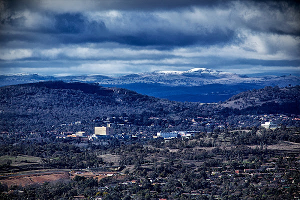
This in from Ben Dover, can anyone help him find the snow?

I took this this morning, looking from Stromlo, across Woden. Does anyone know which hill the snow in the distance is on?

Cheers M’dears.

B-D

Join the conversation

21
All Comments
  • All Comments
  • Website Comments
LatestOldest

Pork Hunt said :

RedDogInCan said :

dungfungus said :

As I said, Yarrow Pic.

Nope, much further out. Using Hey What’s That, the peak is the 1200m Mount Palerang, about 55km away and halfway between between Captains Flat and Braidwood.

No way is that Mt Palerang Sir.
After consulting my HEMA maps on the computer, they are Yarrow Peak and Mt Molonglo in my opinion.
Mt Palerang is in Tallaganda forest and thus covered in trees.

I have just taken a close up photo of Yarrow Pic from a 1950 FCC map.
If someone will tell me how to send the photo I will follow through.
It appears to be about 3 mile west of the Carwoola school and 4 miles north of Mt Molonglo.

RedDogInCan said :

dungfungus said :

As I said, Yarrow Pic.

Nope, much further out. Using Hey What’s That, the peak is the 1200m Mount Palerang, about 55km away and halfway between between Captains Flat and Braidwood.

No way is that Mt Palerang Sir.
After consulting my HEMA maps on the computer, they are Yarrow Peak and Mt Molonglo in my opinion.
Mt Palerang is in Tallaganda forest and thus covered in trees.

dungfungus said :

As I said, Yarrow Pic.

Nope, much further out. Using Hey What’s That, the peak is the 1200m Mount Palerang, about 55km away and halfway between between Captains Flat and Braidwood.

molongloid said :

molongloid said :

That’s Mt Campbell.

Oops. Not Mt Campbell (-35.49663,149.18518). Agree it’s Yarrow Peak (-35.43084,149.32965).

Double oops. Better coords for Campbell are -35.50414,149.19572

molongloid said :

That’s Mt Campbell.

Oops. Not Mt Campbell (-35.49663,149.18518). Agree it’s Yarrow Peak (-35.43084,149.32965).

Ben_Dover said :

Thanks all!

I may try a trip out to Yarrow Pic area on my next day off, will post images if I do.

The resident RA photographer! They should be paying you…

Perhaps you could try this link,oh and I think it’s actually Yarrow Peak

http://www.bonzle.com/c/a?a=p&p=33300&cmd=sp

dungfungus said :

Good map here: http://www.carwoola.org.au/carwoola_map
Drive up the top of Radcliffe Estate.

Where on that map is Yarrow pic mate, thanks for the map, but I cannot see where it is.

Ben_Dover said :

Thanks all!

I may try a trip out to Yarrow Pic area on my next day off, will post images if I do.

Good map here: http://www.carwoola.org.au/carwoola_map
Drive up the top of Radcliffe Estate.

What about a snowy hikes? Any mountains with easy access and a white cap?

Thanks all!

I may try a trip out to Yarrow Pic area on my next day off, will post images if I do.

sepi said :

there is heaps of snow around, but no easy ways to pop out and see some.

Corin forest is covered (see this pic
http://www.canberratimes.com.au/act-news/cold-snap-expected-to-continue-early-in-the-week-20130721-2qcyd.html )

but they are closed, as they cna’t handle the crowds.

there must be some way they could do it. Loads of people just want to pop out somewhere, throw a couple of snowballs and go home, without driving all the way to cooma.

I’d be interested to know where you heard that explanation.

Last year I had a chat to some people from TAMS who had just shut the gate. Their explanation was as soon as there’s a couple of cm of snow over the road, they need to send people home and close it. There was only a handful of people and it was mid-week so definitely not a crowd issue.

there is heaps of snow around, but no easy ways to pop out and see some.

Corin forest is covered (see this pic
http://www.canberratimes.com.au/act-news/cold-snap-expected-to-continue-early-in-the-week-20130721-2qcyd.html )

but they are closed, as they cna’t handle the crowds.

there must be some way they could do it. Loads of people just want to pop out somewhere, throw a couple of snowballs and go home, without driving all the way to cooma.

The Talleganda Ranges behind Hoskinstown were dusted for most of the day, but they have thick trees on, and that hill’s bare. Might be the line rearing out of Googong maybe.

troll-sniffer said :

patrick_keogh said :

Looks like the ridge line out behind Googong Dam. The peaks there are just over 1000m so plenty high enough to have snow.

Yep.. Draw a line in Google Earth to the right of the hospital from Stromlo and you end up in the higher country between Googong Dam and Wanna Wanna Road. Interesting that they look so high from that telephoto angle.

As I said, Yarrow Pic.
http://itouchmap.com/?c=as&UF=-1611769&UN=-2275074&DG=MT

troll-sniffer9:50 pm 21 Jul 13

patrick_keogh said :

Looks like the ridge line out behind Googong Dam. The peaks there are just over 1000m so plenty high enough to have snow.

Yep.. Draw a line in Google Earth to the right of the hospital from Stromlo and you end up in the higher country between Googong Dam and Wanna Wanna Road. Interesting that they look so high from that telephoto angle.

That is Yarrow Pic.

patrick_keogh2:17 pm 21 Jul 13

The highest peak in that area is Yanununbeyan (in the N.P. of the same name) which I think is about 1200m.

That’s Mt Campbell.

It may be the Tinderry Range. I would say you are looking southeast from Mt Stromlo. The saddle in the foreground looks like part of the Red Hill-Isaacs Range between Mugga Quarry 1 (visible, but shaded) and Mugga Quarry 2 (not visible).

patrick_keogh2:13 pm 21 Jul 13

Looks like the ridge line out behind Googong Dam. The peaks there are just over 1000m so plenty high enough to have snow.

Daily Digest

Want the best Canberra news delivered daily? Every day we package the most popular Riotact stories and send them straight to your inbox. Sign-up now for trusted local news that will never be behind a paywall.

By submitting your email address you are agreeing to Region Group's terms and conditions and privacy policy.