27 December 2011

What's this in Googong?

| johnboy
Join the conversation
14
googong dam

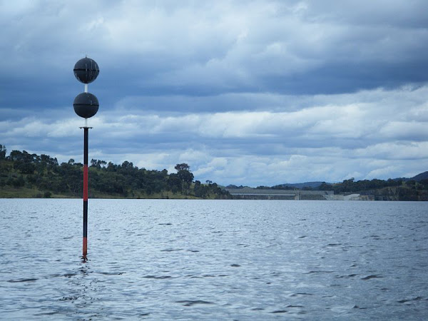
PoQ has sent in this picture asking who can explain it:

While canoeing on Googong Dam, I noticed this.

What is it?

An automatic level indicator?

A signpost for aliens?

It was in a fairly shallow part of the dam, within about a mile (1600 m for younger viewers) of the dam wall.

Join the conversation

14
All Comments
  • All Comments
  • Website Comments
LatestOldest
Rawhide Kid Part32:41 pm 28 Dec 11

I’m surprised that no-one has said submarine.

Ok…. A submarine water pipe to Bungendore. I know… It’s the silly season. Have a Happy New Year to all and sundry.

EvanJames said :

p1 said :

There is a waterways guide? I’m pretty sure there is no required skill level for kayaks, just like there is no required license/Rego/plates on your nazi bicycle.

There should be a required skill level for kayaks. I wonder how much this little exercise cost?
http://www.canberratimes.com.au/news/local/news/general/family-trio-escapes-kayaking-tragedy/2404741.aspx

Maybe. What we really need it a test and licence before people are allowed out in public, or to breed, or to post on the Internet.

p1 said :

There is a waterways guide? I’m pretty sure there is no required skill level for kayaks, just like there is no required license/Rego/plates on your nazi bicycle.

There should be a required skill level for kayaks. I wonder how much this little exercise cost?
http://www.canberratimes.com.au/news/local/news/general/family-trio-escapes-kayaking-tragedy/2404741.aspx

Clear_waters said :

It is the top of the underwater island! during the drought we laughed at the need for such a warming device when it was at the top of a hill and we were some way below it.

Who’s laughing now? 🙂

p1 said :

dr phil said :

If you don’t know what it is you shouldn’t be in the water…. Time you read a waterways guide before taking ANYTHING out onto the water.

There is a waterways guide? I’m pretty sure there is no required skill level for kayaks, just like there is no required license/Rego/plates on your nazi bicycle.

Yes, there is indeed a waterways guide. You are right, there is no required skill level for kayaks, however there are still rules controlling their use, with regards to things such as life jackets and distance from other water users.

You can check out the waterways guide online at http://www.maritime.nsw.gov.au, look for the recreational small boating handbook, or you can even pop into the maritime office in Queanbeyan and grab the actual book.

dr phil said :

If you don’t know what it is you shouldn’t be in the water…. Time you read a waterways guide before taking ANYTHING out onto the water.

There is a waterways guide? I’m pretty sure there is no required skill level for kayaks, just like there is no required license/Rego/plates on your nazi bicycle.

Clear_waters7:57 pm 27 Dec 11

It is the top of the underwater island! during the drought we laughed at the need for such a warming device when it was at the top of a hill and we were some way below it.

If you don’t know what it is you shouldn’t be in the water…. Time you read a waterways guide before taking ANYTHING out onto the water.

Gungahlin Al7:26 pm 27 Dec 11

I believe it is diametrically opposite Cardiff, so it is probably the access trigger for the Rift.

Rawhide Kid Part36:23 pm 27 Dec 11

It marks the secret water pipe to Bungendore

It’s the arrow that got the town guard in the knee, when he used to be a boating adventurer like you.

It’s an “isolated danger” marker/buoy. I would expect that there is a large rock under that marker, posing a threat to marine vessels.

http://www.sa.gov.au/subject/Transport,+travel+and+motoring/Boating+and+marine/Boat+and+marine+safety/International+boating+rules/Buoys%2C+beacons+and+marks/Isolated+danger+marks

Sorry, I don’t have my imagination turned on today :\

Check out http://www.maritime.nsw.gov.au/sbh/safety_on_the_water/navigationsigns.html in the section ‘Other buoys and signs’.

That buoy signifies an isolated danger immediately below the device, probably a large tree or rock or something similar.

An unusual marker indeed, but easily explained. That is an isolated danger marker. Beneath the water will be some sort of boating hazard.

You can find more navigation markers here: http://www.sailingissues.com/navcourse9.html

Stinger

Daily Digest

Want the best Canberra news delivered daily? Every day we package the most popular Riotact stories and send them straight to your inbox. Sign-up now for trusted local news that will never be behind a paywall.

By submitting your email address you are agreeing to Region Group's terms and conditions and privacy policy.