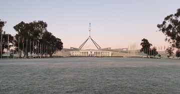
Based on the forecasts for the rest of July, the running average maximum temperature could be a full one degree warmer than the previous record. Photo: Lizzie Waymouth.
It’s been a month of extremes, with warm days, low rainfall and cold nights – as of Thursday (27 July), Canberra had recorded its 12th consecutive night of below-zero temperatures.
However, the capital is looking set to record the warmest average maximum temperatures in July since records began in 1939, according to Weatherzone.
As of 25 July, the running average maximum temperature for the month is 14.1 degrees Celsius. The current record, set in 2019, is 13.7 degrees. In comparison, Canberra’s average July maximum temperature is 12.7 degrees.
“With less than a week remaining until the end of July and relatively warm northwesterlies buffeting the city on Sunday, there’s no end to the unseasonably warm days in sight,” Weatherzone’s Anthony Sharwood said on Wednesday.
The maximum temperatures forecast for the remainder of the month are 16 degrees on Wednesday and Thursday, 15 degrees on Friday, 17 degrees on Saturday, 18 degrees on Sunday and 17 degrees on Monday.
“And based on forecasts for the next six days, the running average max could end up in the mid-14 degree range, breaking the old record by close to a full degree,” Mr Sharwood said.
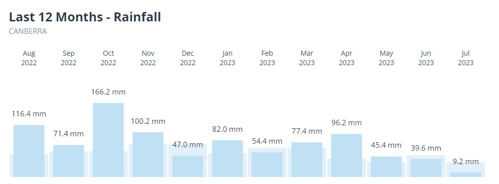
It’s also the first time in 2023 when rainfall has been lower than the monthly average, and the second time in the past 12 months.
“Canberra has had just 9.2 mm of rain for the month to date, due largely to rain-bearing frontal systems staying well south of the Australian mainland. This is also why the snowfields have barely had a top-up of late,” Mr Sharwood said.
Looking ahead, the Bureau of Meteorology (BOM) expects below-median rainfall for much of the country from August to October.
In its most recent rainfall climate outlook released on 20 July, BOM said below-average rainfall was likely to very likely (60 per cent to greater than 80 per cent chance) for most of Australia.
But that’s only part of the story: as you might have noticed, we’ve been having some cold nights and often the day has started with a blanket of frost.
“Canberra has been locked in a pattern of dry days with minimal rainfall … and cold frosty nights,” Mr Sharwood said.
While he pointed out frost was “hardly newsworthy”, especially considering the average July minimum temperature of 0.1 degrees Celsius, it was unusual to have so many frosty days in a row.
“Usually, Canberra gets a break from frost after a few nights as rain-bearing weather systems move through the ACT, raising the humidity and night-time temperatures. Not so much this July,” he said.
As of Thursday (27 July), the capital’s had 12 consecutive days of sub-zero temperatures. While a freezing cold morning isn’t particularly unusual for Canberrans, there have only been four streaks of sub-zero minimum temperatures lasting longer than 10 nights over the past 30 years.
As of Wednesday, Canberra’s running minimum temperature for July is -0.6 degrees Celsius.