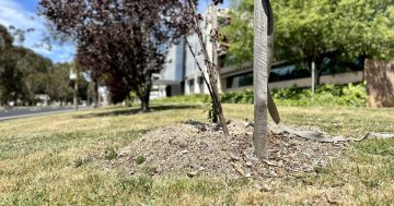
Tree roots can cause significant damage to Canberra’s water and sewer pipes. Photos: Icon Water.
Canberra green thumbs can now check where underground water and sewer pipes are located before they plant trees in their backyard.
Icon Water has gone live with a real-time map of the whole city’s subterranean waterworks which can be viewed on the ACTMapi digital platform.
While the online mapping system is crucial for those planning building works or putting in a swimming pool, Icon Water’s environment and sustainability manager Ben Bryant says it’s also a very useful tool for domestic gardeners because roots of poorly placed trees can cause havoc for the city’s water and wastewater networks.
Tree roots sense water and will find pipes, and investigate along them. If they find so much as a hairline crack, they’ll reach in, then expand, causing blockages and even burst pipes – not a great feature for your backyard or street.
While he encourages residents to plant trees in their yards to help cool the city, Mr Bryant says residents need to be careful where they plant vegetation.
“We want to have a beautiful, green, flourishing Canberra, but we need to ensure those trees are put in the right place,” he says.
“Canberra has a hot, cold and dry climate, so tree roots will spread a long way in search of water.
“Exotic trees in particular will search out the water and nutrients found in our wastewater.”
Mr Bryant says the new layered map is easy to use and provides valuable information about what’s under the ground, so people can make a conscious choice about what they plant on top.
Root intrusion can cause pipes to block or burst and, if a tree falls, it can create a system outage that impacts the entire community.
He says tree roots, combined with items that shouldn’t be flushed down the loo, such as sanitary products and wet wipes, can mean double trouble for Icon Water’s blockage busters who clear and repair damaged pipes.
Using the ACTmapi platform, householders can select the Icon Water layer and zoom into their street or property to see where fresh water pipes flow and also where wastewater flows out to the Lower Molonglo Water Quality Control Centre (LMWQCC).

ACTMapi shows Icon Water’s drinking water pipes (blue) and wastewater pipes (gold). Photo: Icon Water.
The platform showcases a range of ACT Government geographic information from flooding to zoning, but the move to put subterranean infrastructure for all to see is a rarity.
Mr Bryant says you’ll have to look to Texas or Adelaide to find a similar underground map.
“We’re excited to be one of the leaders on this kind of transparency.
“Icon Water is committed to being open and easy to do business with, and ACTmapi helps bring Canberra’s water and wastewater network into an integrated, up-to-date map for strategic planning and development for CBR.”
He says Canberra gardeners will appreciate being able to check pipes in a clear map form, which might guide their planning around tree plantings, positioning a shed and the like.
“More than anything, this is about supporting our community to have a visual guide on water and wastewater assets in their streets and backyards.
“After all, protecting utility assets in green spaces across the Territory is essential for taps to flow and toilets to flush every day.
“We also hope this gives the public a greater appreciation of what is in place to provide drinking water and deliver public sewerage services.”
The new Icon Water data at actmapi.act.gov.au also has an important prompt encouraging users to conduct a free Before You Dig Australia request online prior to any excavation, which helps protect lives and avoids service interruptions.
The map does not include pipelines from individual properties that are connected to the Icon Water network.
Check out the ACTmapi viewer where anyone can have a look at where the Icon Water pipes run through their yard.


