8 December 2010

Severe Weather warning

| sid
Join the conversation
7

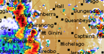
Looks like more bad weather is on the way – the BOM have issued another severe weather warning to follow last week’s fun and games. Also listed on their website is a severe thunderstorm warning for most of the state west of Naranderra – seeing that’s the direction most of our storms seem to come from I imagine they’ll follow up with a thunderstorm warning for the ACT later in the arvo as well?

From the BOM:

Severe Weather Warning
for damaging winds and flash flooding
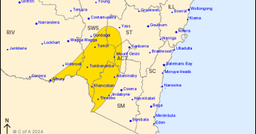
for people in the Riverina, Upper Western, Australian Capital Territory, South Coast, Lower Western, Central West Slopes & Plains, South West Slopes, Snowy Mountains and Southern Tablelands forecast districts

Issued at 12:31 pm EDT on Wednesday 8 December 2010.

Weather Situation
Low pressure trough approaching western NSW with a very humid northerly airflow preceding it.

Damaging winds averaging 50 km/h with peak gusts around 100 km/h are forecast for the Alpine areas of the Snowy Mountains forecast district.

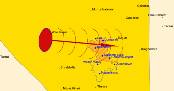
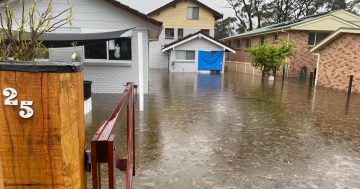
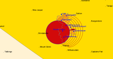
Heavy showers and thunderstorms may lead to flash flooding in the Upper Western, Riverina, Lower Western, and South West Slopes during today, and in parts of the Central West Slopes and Plains, Southern Tablelands and the Snowy Mountains and ACT forecast districts overnight and Thursday morning.

86 mm recorded to 9am at Lake Victoria. 53 mm recorded to 5am at Gambolalley Station

The State Emergency Service advises that people should:

  • Move vehicles under cover or away from trees.
  • Secure or put away loose items around your house, yard and balcony.
  • Keep clear of fallen power lines.
  • Don’t drive, ride or walk through flood water.
  • Keep clear of creeks and storm drains.

For emergency help in floods and storms, ring your local SES Unit on 132 500.

Join the conversation

7
All Comments
  • All Comments
  • Website Comments
LatestOldest

Bit of heavy rain in the inner north and the odd lightning/thunder crash, but nothing too serious just yet.

By that point in proceedings it had already rained well over 2 inches in Tuggers, most of which fell between 11 and midnight. Another huge storm in the wee small hours too. I was just hoping it wouldn’t hail again!

Yep lots of water just sitting on top of the ground and a very full pool – should have been a nice view for those on the hills.

I see our region and the mountains had high readings last night. Also out to Wagga Wagga with 68 so far – send boats. I have 36 at Nicholls – making 1050 for the year.
http://www.bom.gov.au/hydro/flood/nsw/index.shtml

Holden Caulfield1:23 am 09 Dec 10

and it’s arrived.

Bit of heavy rain in the inner north and the odd lightning/thunder crash, but nothing too serious just yet.

and it’s arrived.

They’ll probably cancel the STW just before the storms hit (as usual). We’ll see isolated storms and showers all this afternoon and evening. When the trough arrives, which seems to be slated for the early hours of the morning, we should see some thunderstorm activity and going by the current humidity, it could be quite “interesting”.

Cool! I’m off to buy a kayak.

They’ll probably cancel the STW just before the storms hit (as usual). We’ll see isolated storms and showers all this afternoon and evening. When the trough arrives, which seems to be slated for the early hours of the morning, we should see some thunderstorm activity and going by the current humidity, it could be quite “interesting”.

Daily Digest

Want the best Canberra news delivered daily? Every day we package the most popular Riotact stories and send them straight to your inbox. Sign-up now for trusted local news that will never be behind a paywall.

By submitting your email address you are agreeing to Region Group's terms and conditions and privacy policy.