21 May 2012

The weather radar revealed

| LSWCHP
Join the conversation
35
weather radar

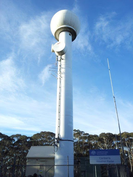
Here’s a picture of the Canberra Region weather radar operated by the Bureau of Meteorology. I thought this might be of interest to a few people. The radar is located in the Tallaganda State Forest south east of Canberra. It’s something that most people I know use all the time, but nobody has ever seen.

For those who like to get their geek on, it’s a WSR-74S. WSR stands for “Weather Surveillance Radar”, the “74” indicates the year the first system was produced and the “S” suffix indicates that it operates at S-band in the RF spectrum, which is around 10cm wavelength or 3GHz frequency. The alternative WSR-74C operates at C-band.

These guys are pretty old, and Wikipedia tells me that they’ve mostly been replaced in the US by the WSR-88D.

Join the conversation

35
All Comments
  • All Comments
  • Website Comments
LatestOldest

I’ll say again that wind farms are hard for doppler radars to deal with. Some of the smartest people on the planet (not including me) work in the radar world. If doppler spoofing from windfarms was an easily solved problem, it would’ve been solved long ago I can assure you.

The issue is that all the signal processing system has to work with is the pulse envelope compression or expansion caused by a moving target. And the doppler from one moving object is pretty much the same as that from another moving object. So the doppler from a moving wind farm rotor looks very very very similar to that from any other moving object.

It can be fixed via clutter maps for example, which say “this area always produces bogus doppler so ignore it”, but that tends to throw out the baby with the bathwater, in the sense that good signal may be discarded with the bad.

At the end of the day, the simplest solution is for a human to look at the signal and say, “Meh…that ain’t no rain, that’s the Lake George wind farm”.

thebrownstreak693:40 pm 22 May 13

KB1971 said :

Does anybody find it spooky that it is 12 months to the day since the last post?

No.

KB1971 said :

Does anybody find it spooky that it is 12 months to the day since the last post?

It’s not spooky but rather par for the course for a government department to get anything done and then stuff it up.

Does anybody find it spooky that it is 12 months to the day since the last post?

HiddenDragon11:05 am 22 May 13

It was a bit scary when it was off the air recently – now I can get back to worrying about what it tells me.

Growling Ferret said :

The recent upgrade worked at the Captains Flat BOM Radar. It now permanently records the windfarms at Gunning, Bungendore and out towards Crookwell as storm activity.

The Gunning wind factory was shown on the CF radar since the day the blades there started turning (read comment #9). As other wind factories have since been commissioned (such as the one at Conroy’s Gap near Yass) they “paint” regularly as does the one at Collector and occasionally the one on the eastern shore of Lake George.
All the radar “upgrade” appears to have done is to intensify the images reflected by the wind factories.
Someone else suggested the only way to avoid this is to replace the radar entirely but the BOM have instead tried to do a software upgrade and it appears to have failed.

Growling Ferret8:22 am 22 May 13

The recent upgrade worked at the Captains Flat BOM Radar. It now permanently records the windfarms at Gunning, Bungendore and out towards Crookwell as storm activity.

p.s. this map will get you there, and lots of other places too http://www.environment.nsw.gov.au/resources/parks/southTallagandaDraftOperations.pdf

dvaey said :

Deref said :

Very cool – thanks!

But I thought it was a Captain’s Flat.

Captain’s Flat Rd is the access road to the radar tower. The tower is approx 10km from Captain’s Flat.

These directions aren’t much help, as CF Road runs 40km to CF from Queanbeyan, and another 25 East of CF towards Braidwood. And the weather radar isn’t signposted. Someone else has posted more precise directions – use them.

IP

LSWCHP said :

EvanJames said :

That’s a good picture, which road do you take to get to it? I have always wondered.

Head out to Captain’s Flat via Quangers. Continue on the Captain’s Flat road towards Braidwood for about 9km. You’ll end up at the crest of the Great Dividing Range, with a turnoff on the right which is the Cowangerong Fire Trail. There’s an information stand at the turnoff with a map and info about the forest flora and fauna. Follow the fire trail about 4.5 km, and there it is. I legged it, but it’s a pretty hefty climb, about the same is climbing Black Mountain from the lake. However, it’s an easy 4wd trip, or bouncy 2wd if you don’t care too much about your car. 🙂

It’s the highest peak in the Range for a long way in any direction, which is why the radar is there. You can stand on the trail with the ground sloping away on both sides, with the Shoalhaven valley on one side and the Tinderry hills on the other side. Fantastic views and it’s absolutely peaceful…not a sound except for some birds chirping and the odd startled roo bouncing away through the scrub.

I can’t recommend it highly enough for a bit of a bushwalk or 4wd trip with a picnic.

There is actuallly another left turn off the Cowangerong Fire Trail – miss it and you’ll end up somewhere else. Watch out for trail bikes on the weekend. Generally they’re in groups, so if you see one, expect others.

As a local, I object to the sign saying “Canberra Weather Radar” and have embryonic plans to remodel it one day.

It’s always worth checking a local website when you want information about something http://www.captainsflat.org/links.htm#Weather

IP

dvaey said :

Deref said :

Very cool – thanks!

But I thought it was a Captain’s Flat.

Captain’s Flat Rd is the access road to the radar tower. The tower is approx 10km from Captain’s Flat.

🙂 Thanks.

AsparagusSyndrome said :

It looks like a thingy.

I suspect that’s what Woody MC was getting at. 🙂

However, I’m compelled to observe that it bears only the very faintest resemblance to a penis. I’m reminded of a friend of mine who once said that E-Type Jags looked like penises. I told him that if his penis looked looked an E-type Jag he should go and see a doctor immediately.

In a similar vein, if the thingy that you’re most familiar with (yours or a friends) emits a loud humming noise and has a couple of microwave dishes halfway up the shaft, well, seek help now. 🙂

AsparagusSyndrome said :

It looks like a thingy.

I know! That is quite obviously the handle for a giant poker machine…

AsparagusSyndrome10:33 pm 21 May 12

It looks like a thingy.

Snarky said :

Thanks LSWCHP, that’s interesting.

Not a weather geek myself, but going by your terminology explanation there, the replacement WSR-88D was first built in 1988, which isn’t really a great deal younger than a ’74. Has nothing improved in weather surveillance the last 24 years?

Not much, really. It’s not like the desktop PC world. 🙂

The radar field is mind-bogglingly difficult to work in. Sonar is harder (hats off to you, sonar guys), but radar is still pretty tough.

The technical challenges are enormous, and advances are very slow. The fundamental concepts were all hashed out a long time ago, and most advances are made in areas such as mechanical reliability or space and weight reduction rather than increased capability.

For example, the very large and expensive SPY-1 phased array radar currently being installed on the Navy’s flash new air warfare destroyers was orginally developed back in the 1970’s. The computing platforms and other underlying technologies have improved, but the concept is pretty much unchanged over the last 40 years.

The same goes for weather radars. Once you’ve approached the boundaries of the laws of physics there’s not a whole helluva lot more you can do. I will note thought that the Australian weather radar network isn’t completely homogenous. There seems to be a variety of different devices in service, but I haven’t spent much time researching them as I was only interested in the Canberra station.

GardeningGirl9:42 pm 21 May 12

Thanks LSWCHP, and everyone, for sharing. Very interesting.

Ben_Dover said :

Sounds neat! I should take a drive out there with my box brownie.

Do it. There’s more scenic photo ops up there than you could poke a wooly bull at.

dungfungus said :

BOM still haven’t fixed the software to stop it showing the Gunning wind factory (why do they call them farms?) on days when it is generating.

I know a bit about radars. The windfarm problem is a long standing worldwide hassle for all sorts of radars, and it’s much harder to solve than you might imagine.

Furthermore, as this is a very old US radar, I doubt whether anyone in Australia has the source code for the software. The hardware is probably some long-forgetten ancient device with the code written in some language that nobody in Australia has ever heard of. Even if they did have the source, I doubt whether they have the rights to the intellectual property that would allow them to modify the source.

So, I might be wrong, but I reckon the only thing that will fix that problem is a new radar.

EvanJames said :

That’s a good picture, which road do you take to get to it? I have always wondered.

Head out to Captain’s Flat via Quangers. Continue on the Captain’s Flat road towards Braidwood for about 9km. You’ll end up at the crest of the Great Dividing Range, with a turnoff on the right which is the Cowangerong Fire Trail. There’s an information stand at the turnoff with a map and info about the forest flora and fauna. Follow the fire trail about 4.5 km, and there it is. I legged it, but it’s a pretty hefty climb, about the same is climbing Black Mountain from the lake. However, it’s an easy 4wd trip, or bouncy 2wd if you don’t care too much about your car. 🙂

It’s the highest peak in the Range for a long way in any direction, which is why the radar is there. You can stand on the trail with the ground sloping away on both sides, with the Shoalhaven valley on one side and the Tinderry hills on the other side. Fantastic views and it’s absolutely peaceful…not a sound except for some birds chirping and the odd startled roo bouncing away through the scrub.

I can’t recommend it highly enough for a bit of a bushwalk or 4wd trip with a picnic.

Deref said :

Very cool – thanks!

But I thought it was a Captain’s Flat.

Captain’s Flat Rd is the access road to the radar tower. The tower is approx 10km from Captain’s Flat.

BoM’s info on the fancy new Doppler ones: http://www.bom.gov.au/other/doppler/adelaide/index.shtml

Deref said :

Very cool – thanks!

But I thought it was a Captain’s Flat.

Where, on the bar at the CF pub?

Captains Flat is close enough to Tallaganda State Forest to allow it to be the postal address for the radar. If you type Tallaganda into the maps app on an I-device you’ll end up at a service station in Braidwood.

Thanks LSWCHP, that’s interesting.

Not a weather geek myself, but going by your terminology explanation there, the replacement WSR-88D was first built in 1988, which isn’t really a great deal younger than a ’74. Has nothing improved in weather surveillance the last 24 years?

Gungahlin Al said :

I always wondered… Now I know. Thanks!

In Brisbane they also have wind doppler, which can produce pretty amazing pictures during storms. So perhaps it’s a newer setup.

+1

Yes, doppler wind would be great for us storm enthusiasts. In the case of The Gap microburst storms of 2008 (keep watching through to the end), doppler wind images provided quite useful information for one of the most powerful electrical storms Brisbane had seen.

And you can see if your location is about to get hammered if the BoM updates are not frequent enough.

Woody Mann-Caruso5:59 pm 21 May 12

*girly squeal*

Very cool – thanks!

But I thought it was a Captain’s Flat.

BOM still haven’t fixed the software to stop it showing the Gunning wind factory (why do they call them farms?) on days when it is generating.

That’s a good picture, which road do you take to get to it? I have always wondered.

Sounds neat! I should take a drive out there with my box brownie.

For the weather geek in me the impressive thing is that it’s located at the top of a ridge, around 1200-1300 m above sea level. Which is v high for a structure like this – it’s the highest of the BOM radar sites in Australia, and is arguably the most reliable with an uninterrupted view in all directions

Excellent! What road do you take to get to it?

Gungahlin Al4:48 pm 21 May 12

I always wondered… Now I know. Thanks!

In Brisbane they also have wind doppler, which can produce pretty amazing pictures during storms. So perhaps it’s a newer setup.

We took a drive out there last winter, drove up the fire trail to it and it started to snow.. Very pretty, but very exposed site.

Thanks for sharing. That is pretty cool and yes I did get my geek on and look it up 🙂

Daily Digest

Want the best Canberra news delivered daily? Every day we package the most popular Riotact stories and send them straight to your inbox. Sign-up now for trusted local news that will never be behind a paywall.

By submitting your email address you are agreeing to Region Group's terms and conditions and privacy policy.