Customers with umbrellas making the morning coffee run in Canberra. Photo: File.
As parts of NSW endure flooding from the current big wet, the ACT and Queanbeyan have not been spared as dams in the region have hit 100 per cent capacity.
And the deluge isn’t over yet, with at least 50-90mm of rain forecast to fall in the ACT on Tuesday, 23 March. The Bureau of Meteorology has also included the ACT in a severe weather warning.
Googong Dam, near Queanbeyan, reached 100 per cent capacity in the past 24 hours, however, there is no immediate risk of flooding downstream as the slow and steady rain keeps Queanbeyan River flowing within its confines.
On Monday, 22 March, the smallest of the region’s four water catchment dams, Bendora Dam, hit 100 per cent capacity after 26mm of rain fell there in the past 24 hours.
A spokesperson for Icon Water said Canberra’s four dams are currently at 100 per cent capacity.
“With ongoing rainfall and inflows, our overall capacity has reached 100 per cent for only the second time since completion of the enlargement of the Cotter Dam in 2013,” said the spokesperson.
“With nearly 20mm of rain recorded during the weekend and more on the way, Googong, Cotter and Corin dams are all at 100 per cent of capacity and spilling.”
However, there is no risk of flooding in the area, although people are being urged to remain cautious.
“As each of the dams reach capacity, water naturally topples over the spillways,” said the spokesperson. “This is what is currently occurring at Googong, Corin, Cotter and Bendora dams.
“As water storage dams, all four of the ACT’s dams were designed to spill when at 100 per cent.”

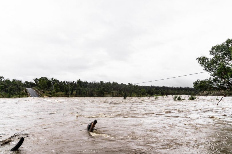
The flooded Shoalhaven River at Bombay, west of Braidwood, on Monday, 22 March. Photo: Jarrah Parsons.
Many roads and causeways in the Queanbeyan-Palerang area are flooded, with the usual message of ‘if it’s flooded, forget it’ being issued to motorists.
Oaks Estate Road, between Queanbeyan and Pialligo Road, was closed on Monday morning (22 March) and is expected to remain closed as the Molonglo River rises steadily. It is currently at 2.7 metres.
The low-lying bridge at Queanbeyan remains open at this stage.
There was also concern for a family of swans and their cygnets after a barrier made from pool noodles was installed across Queanbeyan River to prevent the cygnets from tumbling over the weir. The cygnets have since been rescued by local Wildcare Queanbeyan volunteers.
In the ACT, Point Hut Crossing and Angle Crossing are closed due to elevated river heights.
On the Kings Highway, one westbound lane near Pooh Corner is closed due to a landslip, while the speed limit has been reduced to 60km/h.
There are also reports of a number of minor mudslides and slippages on Clyde Mountain, causing gutters to fill with mud and overflow onto the road. Motorists are being urged to drive with extreme caution.
A landslide has also closed Araluen Road at Knowles Creek, approximately 3.5km north of Larrys Mountain Road, west of Moruya.
The Shoalhaven River is also flowing very fast and has flooded many areas near Bombay, west of Braidwood, where more than 40mm of rain has fallen in the past 24 hours. On Monday, 22 March, it had reached a height of 4.5m and is rising at Warri, also west of Braidwood.
A Queanbeyan-Palerang Regional Council spokesperson said many of the causeways in the area have flooded following approximately 100mm of rain in the past 24 hours.
“There are lots of low-lying causeways in the local government area that are flood-affected,” said the spokesperson. “We have also been undertaking heavy patching on sections of the Kings Highway in recent weeks. Some of these areas are incomplete and are being impacted by the rain.
“We are pleading with drivers to slow down through these sections for the safety of workers trying to make the areas safe and for your own safety.”
But the big question remains – when is the rain going to stop?
The Bureau of Meteorology says the ongoing rain will begin to clear on Wednesday, 24 March, when a low-pressure system in the Tasman Sea begins to move away to the south, delivering a reprieve from the wet conditions of the past week.
Ironically, Monday, 22 March, is World Water Day.


