17 March 2021

Woden CIT, Interchange road plan under fire

| Ian Bushnell
Join the conversation
43
Woden Bus Interchange

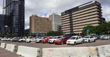
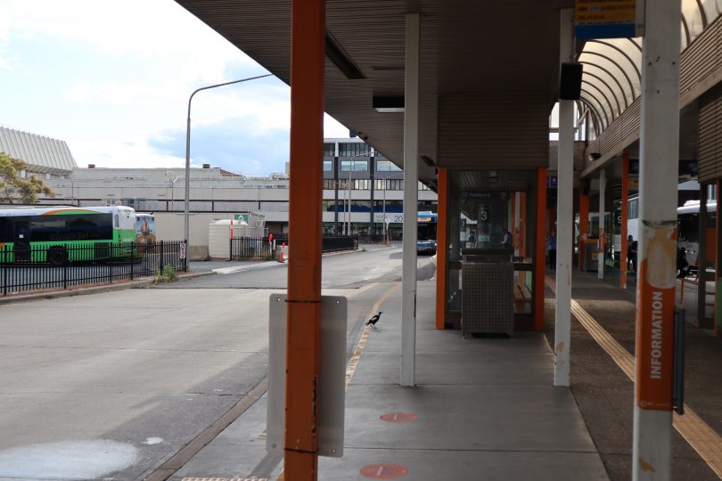
Woden Bus Interchange, looking towards Westfield. Photo: File.

Woden Valley Community Council president Fiona Carrick has slammed a proposal to extend a road across the current bus interchange site in Woden where there is meant to be a pedestrian boulevard from the new CIT and Interchange to the Woden Square.

The proposed Bradley and Bowes Street link would mean pedestrians having to cross a busy road as they head to and from the Square, Westfield shopping centre and the Library.

The road extension was recommended in the traffic study included in the new Woden Interchange development application lodged last month.

Already set to be upgraded from local to collector roads to provide access to the new CIT on one side and Grand Central Towers on the other, connecting the two streets would create a continuous route from Callum Street to Launceston Street.

READ ALSO Government releases list of 76 public schools with hazardous materials

Traffic is expected to surge along surrounding streets including Bowes Street due to the closure of Callum Street, and the traffic study suggests using traffic calming devices and lowering speed limits in the area, particularly near pedestrian thoroughfares.

It recommends the extension of Bradley Street to Bowes Street to alleviate the increased vehicle movements towards Launceston Street.

Ms Carrick said the proposal flowed from the decision to build the interchange on Callum Street, which will cut the major link between Hindmarsh Drive and Launceston Street and necessitate diversions up Bradley Street, and Wilbow Street through to Easty Street.

Proposed new layout

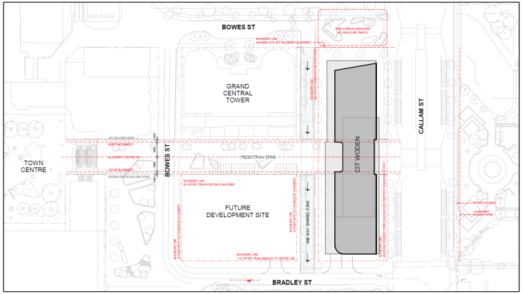
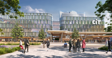
A map showing how the proposed new layout might work. Image: CIT Design Report, 2020.

Ms Carrick said the road proposal was part of a planning mess that would disrupt the east-west pedestrian corridor, clog the area with traffic and be detrimental to the function of the Town Centre.

“You’re just blocking up the centre of Woden when that should be open and free for the people,” she said.

Ms Carrick said it was also being driven by the need for more access to and from the newly completed Grand Central Towers on the northern side of the current interchange.

She mocked the notion of a boulevarde when it will be cut by a road, shaded by Grand Central Towers and the morning sun will be blocked by the new CIT.

READ ALSO Why women supporting women might be just what the ‘Canberra bubble’ needs

“Would you hang out there? Would you be attracted to that area in the shade and cold?” she asked.

While the interchange may be dilapidated, she said its loop system, a common feature of bus interchanges, actually functioned very well as far as bus movements go.

“Why are they getting rid of the bus loop and putting everything through this eye of a needle [in Callum Street]?” she said.

Proposed new Woden Interchange

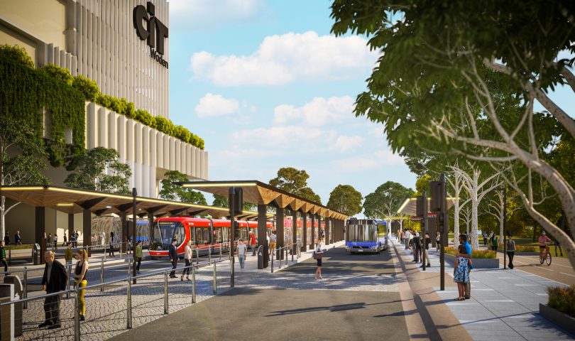
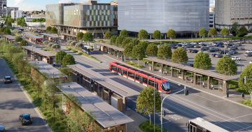
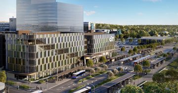
An artist’s impression of the proposed new Woden Interchange. Image: ACT Government.

Ms Carrick said that Callum Street would have to be widened to fit the light rail station and the designs showed the new interchange virtually on top of the Woden Town Park rose garden near where the proposed youth centre is supposed to be sited.

“It’s no wonder they’ve gone quiet on the community centre because that was supposed to be between Callum Street and the drain [Yarralumla Creek],” she said.

Ms Carrick said the government was trying to cram too much into a limited space.

The government has allowed more time for people to comment with the representation period for the interchange, bus layovers, and drivers’ amenity building DAs extended until 16 April.

Join the conversation

43
All Comments
  • All Comments
  • Website Comments
LatestOldest
PlasticScene10:09 pm 31 May 22

I’m not a big fan of the latest social engineering changes to urban design in Canberra. For example, I can rarely visit Chemist Warehouse (or any of the businesses along that street) since parking in the area has been cut in half. ALL of the spaces that used to be along that street were replaced with a bike lane. Is that fair to those businesses or us consumers??

I live in the area, but I am yet to see a SINGLE bicyclist use the bike lane. Instead, the lives of people who are in ill health (there are some of us out there) are made much more difficult and less convenient in the name of some idealistic principle that we can all bike or walk. It’s unfair and unrealistic. And those “unlucky few” can just get a handicapped designation, you say? Those all require a visit to a GP and annoying paperwork that must be renewed frequently (another inconvenience heaped onto people whose lives are already difficult).

I suspect people will just avoid inconvenient locations and the businesses there will suffer. Tax dollars will be at risk too, if businesses find it less profitable to operate in areas without adequate parking.

Please, some consideration that walking, biking, and public transport simply aren’t suitable to all, and city centres are at risk for becoming dead zones if you don’t accommodate cars. Yes, cars! The main mode of transportation that works rain or shine, can transport people’s purchases and children, and can relieve someone in ill health. If you are young and healthy and wish to, by all means, WALK or BIKE! But please be aware that not everyone can, and another principle of good design is ACCESSIBILITY and INCLUSIVITY.

ChrisinTurner9:55 am 19 Mar 21

In Amsterdam buses and trams share platforms in many places. This makes changing modes simple and efficient. People step off their tram from the city centre and their connecting bus pulls in behind the departing tram.

Capital Retro12:19 pm 19 Mar 21

I thought everybody rode bicycles in Amsterdam.

Fiona Carrick7:45 pm 18 Mar 21

We need to look at the traffic modelling to be informed.
VLC Bus Network and Infrastructure Requirements
• “the design brings up numerous safety concerns, regarding which it is suggested that an Operational Risk Assessment is performed to determine whether the facility can operate safely. These are outlined in the following two sections, including potential options for mitigation. While we can flag potential risks as we see them, VLC do not have the engineering qualifications to be able to provide final recommendations regarding the safety of this design. We advise seeking a qualified engineer to provide a more detailed risk assessment.” p40
Types of interchanges across Australia
• Buses run perpendicular to trams, Civic, Gungahlin, Glenelg
• Loop to side of trams, Newcastle, Helensvale (Qld)
• Buses and trams share platform, Kingsford (NSW), Broadbeach (Qld)
• Buses on surrounding streets, Dulwich Hill, Randwick (NSW)
If anyone is aware of a design like Woden’s would they please let me know.
Jacobs CIT Woden Transport Interchange
• “The future transport network of Woden Town Centre should aspire to both respond to the place making priorities and movement requirements of the area. To meet the growing demand in Woden town Centre, network development must be flexible and with a clear outlook of what is required in the future.” p69
• A wider Movement and Place study for Woden Town Centre (at a precinct level), should be undertaken to establish and agree on the role of different roads within Woden and establish an implementation plan to ensure the roads correctly align with their proposed classification.” p78
Traffic volumes along Easty, Wilbow and Bowes streets will surge because of the closure of Callam St. Bradley St will be connected to Bowes St with traffic flowing across the bottom of the stairs to the Town Square.

Jorge Garcia12:54 am 19 Mar 21

Buses perpendicular to Trams (as in Civic) is awful… People running across the street against the traffic light is a common occurrence. The other options do not appear to be feasible to me, as they would involve tearing down existing community values such as the youth center.

The fact that it has not been done quite like it anywhere else does not mean it can’t work. Unique problems require unique solutions.

Right now the main use of Callam Street is to access the car parks. The neighboring streets are already busy with traffic as they are needed to access Callam street before accessing the carparks.

I’m not sure how modelling is going to help… Too many assumptions and guessing about volumes of people using CIT etc… All over the world cities are closing streets to traffic to allow public transport hubs and shared pedestrian/service vehicles – that has been shown to work very well.

There will be pros and cons to every proposal… In the end I keep coming back to the thought that this is a vast improvement on what’s there right now.

Jorge Garcia4:50 pm 18 Mar 21

I have a lot of time for Fiona Carrick, as I agree that there has been too much unfettered development leading to some very big disasters – as reported elsewhere in the RiotACT on several occasions.

However I have looked over the proposal and I have to admit that it looks like it’s a vast improvement on what’s currently there. Bringing the light rail and the CIT into that area alongside the buses that service the area is a stroke of genius, and has the potential of making a currently dead and barren business district into one that is lively accessible and well subscribed.

What would change Fiona’s mind I wonder? Removing the one way lane servicing the towers? (unfair) Removing the CIT? (what a catastrophe that would be!!!) – Removing the light rail terminal and bus interchange?? (these are essential – particularly to service the CIT and he higher density housing already in Woden – light rail to the South will transform this city)

Sorry Fiona, on this occasion I think that you protest too much…

It’s hard to believe anyone is supportive of the current hideous loop bus interchange in Woden. As the revamped bus interchange in Belconnen has shown, a straight line through system is quick and efficient. Currently a bus from civic to Tuggeranong has to three left turns to stop. The current interchange is dangerous, dark, ugly and vile. The quicker the eyesore is demolished the better.

Fiona Carrick11:08 pm 18 Mar 21

Bus movements – see p21 of the VLC traffic modelling report

It is interesting to follow the bus movements through the interchange and layovers.
The traffic modellers forecast 124 buses per hour heading north and 122 heading south in future morning peaks. There will be three double bay stops operating head of queue services (that means first bus in is the first bus out) on the west side and 4 bays on the east side. Buses cannot wait for their next run because that will clog up the interchange. Buses will layover at Phillip Oval and Easty St between services.

Easty St layover (east side) – buses travelling north will access the layover with a right onto Launceston, right onto Easty then right onto Wilbow to head north again. Buses travelling south will drop passengers on the east side of Callam St then left onto Wilbow, do a U turn at the roundabout, then right onto Callam (through the interchange), right onto Launceston and right onto Easty to the layover.

Phillip Oval layover – buses heading north go straight to the layover but to continue north (and pick up passengers) they need to turn left onto Launceston, right onto Easty, right onto Wilbow then right through the interchange. Buses heading south drop passengers on the east side then turn left onto Wilbow, left onto Easty and left on to Launceston to get to the layover.

The existing loop is functional and can be upgraded for amenity. Buses from the south enter the loop, drop passengers and pick them up (between the town square and the interchange) then head south again without passing through the interchange. This is better than walking to the east side of Callam St (across busy bus and tram movements) to catch a bus south.

ChrisinTurner2:53 pm 18 Mar 21

Imagine what we would get if the city planners only spoke to the community and the developers were kept out.

I do not have a problem with the Light Rail coming to Woden. The problem I have is the incredible bad planning that Canberra has had to suffer for at least 10 years. This is another classic example. It is all very well to say the idea is to reduce reliance on cars, that will not happen. They will be cutting Callum Street of completely to cars and the streets they intend to use are not capable of handling the added traffic. I would not like to have bought into Grand Central Towers – OH that’s right these people wont have cars.

Grand Central Towers were advertising the joint with a big whopping banner saying “Light Rail Stops Here!!”. I reckon they’ll be OK.

Fiona Carrick11:13 pm 18 Mar 21

They will be ok if they want to go to the city. What if they do shift work somewhere else in Canberra, what if they need to take a child to basketball in Belconnen at 8pm on a Sunday night? Don’t forget our basketball stadium was demolished so we cannot walk to indoor recreation, or any culture for that matter.

underwhelmed10:45 am 19 Mar 21

Hi Fiona, Why do you keep bring up that the people in Woden need to go to Belconnen to access basketball? Located just over the hill, and only short bike ride/bus trip/car drive, is the Tuggeraong basketball stadium.

I’ve been a vocal opponent of the light rail on economic reasons but the upgrading of this area and reducing future car traffic makes perfect sense from a planning and transport perspective.

The whole idea is to reduce the reliance on car usage in an area that will be well serviced by public transport. And it’s not like they are preventing cars from using the area totally, there will still be numerous other road options available to get in an out of the amenities in the area.

Fiona Carrick11:46 pm 18 Mar 21

While reducing car movements is ideal it is difficult without amenity to walk to in the Town Centre. We have lost the basketball stadium, bowling greens, tennis courts, pitch n putt and the pool and ice rink are the next to go. We do not have a community centre or an arts centre. We are also at risk of losing the service area in Phillip with Magnet Mart and its garden centre closed.
Some people can manage without a car but for many in Woden a car is necessary to get to services and facilities.
Traffic from residential towers should be directed out of the town centre so the internal streets can be shared (like Bunda St) with active fronts and restaurants and cafes. Unfortunately, the new bus interchange will direct traffic along the bottom of the town square stairs and along Bowes St, turning it from a local road (in the traffic hierarchy) to a major collector.
VLC traffic modelling p 70 – “The Woden Town Centre network would greatly benefit from adopting the Movement and Place framework to guide future planning and design, allowing the Town Centre to move towards a more forward-thinking and innovative approach to integrated transport and landscape.”
I hope we listen to the transport modellers about how we can do things better.

underwhelmed12:50 pm 19 Mar 21

The reason that Woden has lost these facilities is they weren’t viable, as Woden doesn’t have the feeder population to support them. As they say, use it or lose it.

It is an idiotic plan to block off a major road thoroughfare and essentially divide the town centre in two halves. The modelling shows it will put excessive pressure on the on already at capacity surrounding roads and seemingly ignored that there’s a police station on the road with police needing to respond to emergencies speeding through the interchange, needing to disburse traffic from Woden Plaza both north and south, residents, school students and workers who will pointlessly need to circle the town centre to come and go.

But then I have little or no confidence that the Government will pay any attention concerns about stupid plans and will just dismiss and carry on doing whatever they want.

The whole point is that it isn’t going to be a major road thoroughfare into the future and cars will slowly be reduced from entering the area, the same way has occurred in Gungahlin with the light rail. There are other road options available, which is what they will push you to use in the future.

The Police will still also be able to use Callam St so it doesn’t really affect their operations at all.

Fiona Carrick12:07 am 19 Mar 21

That is interesting. Does the closure of Hibberson St for light rail (noting there are no buses around it) push cars into the town centre changing local roads into major collector roads in the centre like our Bowes St. Did they lose their opportunity for active fronts –
a type of Bunda St arrangement? It would be ok if the cars were pushed out of the town centre instead of into it (noting they will also be pushed onto Easty St and Melrose Drive)

HiddenDragon8:10 pm 17 Mar 21

All of this unhelpfully logical criticism of what’s in store for the Woden town centre will, of course, be dismissed as nothing more than the backward-looking negativity of NIMBYs, BANANAs and ok, Boomers etc.

On a point of detail, the street at the heart of this debate is probably named after this First Fleet surgeon –

https://peopleaustralia.anu.edu.au/biography/callam-james-30516

not after a British boy band member.

Definitely representative of the entire Woden community. Elected in a landslide. Probably should call the whole thing off.

This is Costigan level stuff.

Daily Digest

Want the best Canberra news delivered daily? Every day we package the most popular Riotact stories and send them straight to your inbox. Sign-up now for trusted local news that will never be behind a paywall.

By submitting your email address you are agreeing to Region Group's terms and conditions and privacy policy.