Dr Price’s research focuses on high ignition zones in the densely settled inner suburbs. Image: Supplied.
We may be going through consecutive polar blasts at the moment, but Canberra’s unique combination of higher-density inner suburbs threaded through with bushland is a combustible mix, according to a newly developed bushfire mapping tool.
Add to that “a lot of ignition” in those areas, and Canberra’s heavily populated areas are at surprisingly high risk for bushfires, according to Dr Owen Price from the University of Wollongong.
Dr Price has used a newly developed bushfire risk prediction tool to map our biggest fuel loads and the likelihood of future bushfires in urban areas.
Initially developed in the Baulkham Hills area in Sydney, Dr Price then assessed Canberra’s risks for his work at the request of ACT Parks and Conservation.
“In the Hills district, most of the bushland is in the north and there’s a fairly clear distinction with closely populated urban areas, whereas Canberra has islands of forest within the town that my analysis highlighted as potential risks,” he says.
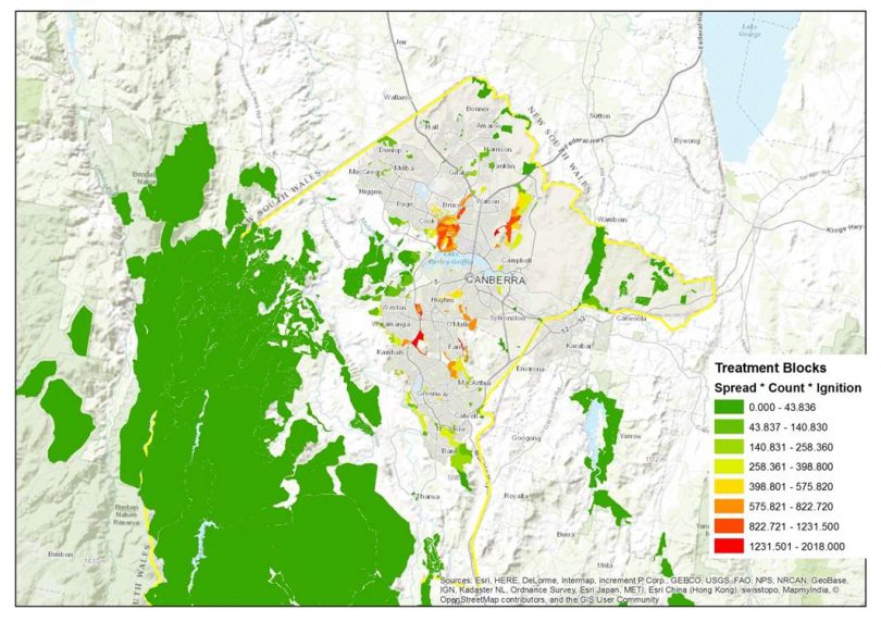
Dr Price points to a confluence of factors: a large concentration of houses, but also an ACT Parks and Conservation map that shows multiple recent incidences of small fires (above).
“The kindest explanation is that it’s carelessness, people tossing cigarettes out of car windows without thinking,” he says. Significantly for fire risks, Canberra’s reserves are islands of natural bush rather than controlled plantings.
Suburbs adjacent to bushland on the city’s southern, western and eastern edges are at an even higher risk than rural areas, according to Dr Price.

The Pierce’s Creek fire late last year was just a few kilometres from the nearest suburb. Photo: Jack Mohr.
His planning tool is something of a world-first, mapping bushfire risk based on objective records of past fire patterns. Dr Price believes that current prediction methods are too simple, often failing to account for varying factors like the amount, distance and direction of forest, fuel reduction from recent fires and ignition hotspots.
Dr Price’s new method considers ignition hotspots, a place’s distance from previous ignition points, the layout of forest in the landscape, time since the last fire, and the weather.
He calculated the risk to Canberra’s suburbs using data from ACT Parks and Conservation and the census. Factors included density, the direction in which houses faced, proximity to bushland and the last time that fuel sources were treated.
“The method takes planning from a heuristic approach where everyone relies on expert opinions and puts it into an objective, repeatable framework that compares one place to another. Fire agencies can then judge whether they’re putting their resources into appropriate places and whether there are any gaps,” he says.
Dr Price is quick to emphasise that there’s plenty of value in expert judgements and that his mapping method is another tool in a mix that often also includes simulator models.
“One of the key judgements is where to do fuel treatments, and this is more than guesswork and expert opinion. All methods have their drawbacks but you have to marry them all together to get the best-informed result.”