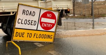
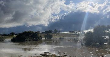
We’re being reminded, ‘if it’s flooded, forget it’. Photo: Claire Fenwicke.
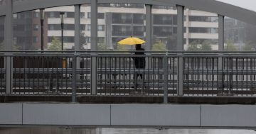
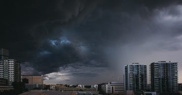
Emergency services are on high alert across the Capital region and NSW with torrential rain and possible storms forecast from now into the weekend.
Two “very significant” weather systems were moving across the region from today (4 October), with school holiday travellers especially warned to keep an eye on conditions when driving back home.
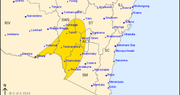
The ACT Emergency Services Agency warned Canberra was expecting anywhere from 10 to 20 millimetres each day from Wednesday (5 October), which could be enough to close roads.
“Areas surrounding the ACT are set to receive significant rainfall over the coming days, so if you are planning to travel, make sure you check road closures before you leave and drive to conditions,” a statement said.
“We could also see a chance of thunderstorms develop over this period.”
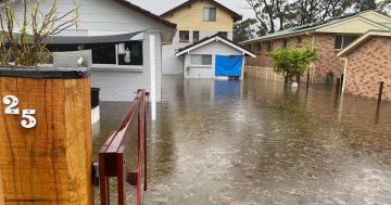
NSW State Emergency Services (SES) Commissioner Carlene York said volunteers had received more than 2,200 requests for help in September alone and performed more than 100 flood rescues.
“It’s really important for the community to remember they have to make safe decisions when travelling around the state,” she said.
“Just overnight, we had a flood rescue in Griffith where four people were required to be rescued after their car was washed away in flood waters.
“My message to the community is if you see water across the road, turn around and take another route.”
Those people had gone in before the road was flooded and discovered they couldn’t get back.
Commissioner York said luckily they were rescued safely, but “it could have been so different”.
“Every flood is different, and so people should not assume that just because they haven’t been affected in the past that they won’t be affected in the future,” she said.
“Have a plan. Now’s the time before these two weather systems come through to make sure everything’s tied down around your house, gutters are cleared, you have an emergency kit ready to go with any important documentation or medication, a torch, a battery-operated radio, and think about what you need to do if you have any animals.”
NSW SES has deployed extra vehicles, boats and volunteers in preparation and has aerial assets on standby.
Local Land Services reminded landowners they have a responsibility for their livestock and had extra preparations they needed to complete in case of flooding.
“We encourage you to identify and move livestock to a ‘safe’ area on your property where they are away from danger but still have access to food and water,” Emergency Management Coordinator Piers Harper said.
“You should remove pumps from waterways, secure moveable objects like bale feeders and, where possible, move farm equipment to higher ground.
“It’s also important to store all chemicals securely and out of potential floodwater levels.”
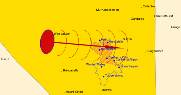
Bureau of Meteorology meteorologist Gabrielle Woodhouse explained the first system had already developed over inland NSW, with a severe weather warning in place for western NSW, including the Riverina.
“This system is expected to move further east and bring moderate to heavy rainfall, quite widespread, to inland areas of NSW today and tomorrow, and then weaken as it moves towards the southeast on Thursday,” she said.
The warning detailed six-hourly rainfall totals of 20 to 30 millimetres were likely, with localised falls up to 60 millimetres possible.
While 24-hour rainfall totals of 40 to 60 millimetres have been predicted, localised falls up to 80 millimetres are possible for the same period.
Ms Woodhouse said this could equate to a month’s worth of rain or even more.
“That is falling on that backdrop of a really, really wet state at the moment,” she said.
“The fact that all of the rivers and the dams and all of the waterways are so full, it means when we have that rain that falls, it doesn’t take much to see that runoff increase quite quickly.
“We could expect local flooding and flash flooding even in those areas away from those river systems which have been in flood for quite some time.”
A flood watch has been issued for the Molonglo, Queanbeyan and Murrumbidgee rivers across the ACT and surrounds, while a minor flood warning has been put out for the Snowy River, with flooding possible at McKillops Bridge from tomorrow morning.
There will be a slight respite before a cold front sweeps in from the west, reinvigorating storm activity for eastern NSW.
For Thursday (6 October), the heaviest rainfall has been predicted to fall around southeast NSW and the South Coast.
As we come into Friday (7 October), rain and thunderstorms, some severe, were expected to rapidly develop through central NSW before the cold front moved to eastern NSW that night.
Further warnings were expected to be issued as the situation developed.
If you need help from the SES, call 132 500. In an emergency, call Triple Zero.