
Reconciliation Day performers at the National Arboretum for the 2021 event. Photo: ACT Government.
Temperatures are set to plummet for Canberra’s Reconciliation Day public holiday, but it’s Tuesday when there’s the potential for a big dumping of snow.
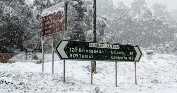
Bureau of Meteorology (BOM) spokesman Jonathan How said, with the official start to winter just around the corner, a powerful cold front is on its way to our region.
“It will deliver rain, squally winds and significant snowfall,” he said.
A mass of cold air from the Bight is due to arrive from Sunday (29 May), bringing with it a run of cold days for the Capital.
But Mr How said Tuesday was the day when things would really cool down.
“The coldest air will push across the east coast [on Tuesday],” he said.
“There’s [also] the potential for snow in the Central Tablelands, including Orange.”
The cold air will push the snow level down to around 700 metres, with 20 to 50cm of powder predicted to hit the ski fields.
There is the potential for severe weather warnings to be issued in the coming days.
It’s as the BOM also released its Winter 2022 Climate Outlook, which shows the Capital and inland areas of NSW are likely to experience a wetter and colder season than usual this year. However the south-east is likely to remain “unusually warm”.
“A slowly weakening La Niña is one climate factor influencing above average winter rainfall for most of central and eastern Australia in coming months,” a statement said.
“The Outlook predicts the unusually wet conditions for inland parts of New South Wales, South Australia, Queensland and the Northern Territory are likely to be in the top 20 per cent of wettest winters.
“With already saturated catchments in south-eastern Australia, the winter rain extends the flood risk for these regions.”
However warmer than average nights are likely “almost everywhere”.
“[There’s] at least an 80 per cent chance of higher minimum temperatures for most of Australia,” the BOM said.
“The winter outlooks reflect several climate influences, including a developing negative Indian Ocean Dipole, a slowly declining La Niña in the Pacific Ocean and warmer than average waters around northern Australia.”
Here’s the forecast for your Reconciliation Day long weekend:
Australian Capital Territory
Saturday 28 May: partly cloudy with a high chance of light showers, most likely in the early morning. Overnight temperatures falling between five and nine degrees, with daytime temperatures reaching between 11 and 16 degrees.
Sunday 29 May: partly cloudy with a chance of morning frost about the ranges. Overnight temperatures falling between 0 and three degrees, with daytime temperatures reaching between nine and 14 degrees.
Monday 30 May: cloudy and windy with a chance of morning frost about the ranges. Very high chance of rain, between 15 to 20mm, with snow falling above 1100 metres. Overnight temperatures falling between 0 and three degrees, with daytime temperatures reaching between seven and 12 degrees.
Australian Alps – Snowy Mountains
Saturday 28 May: high chance of showers, most likely in the early morning, with snow falling above 1600 metres.
Sunday 29 May: partly cloudy with a chance of morning frost. Slight chance of a shower in the west, with possible snow falling above 1500 metres.
Monday 30 May: cloudy and windy with a chance of morning frost. Very high chance of showers, most likely in the afternoon and evening, with snow falling above 1000 metres
South Coast
Saturday 28 May: partly cloudy with a chance of light showers. Overnight temperatures falling between seven and 10 degrees, with daytime temperatures reaching between 15 and 19 degrees.
Sunday 29 May: partly cloudy with light winds. Overnight temperatures falling between three and nine degrees, with daytime temperatures reaching between 13 and 18 degrees.
Monday 30 May: partly cloudy with a chance of morning frost in the south. High chance of showers, most likely in the afternoon and evening with winds picking up. Overnight temperatures falling between two and six degrees, with daytime temperatures reaching between 12 and 17 degrees.