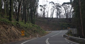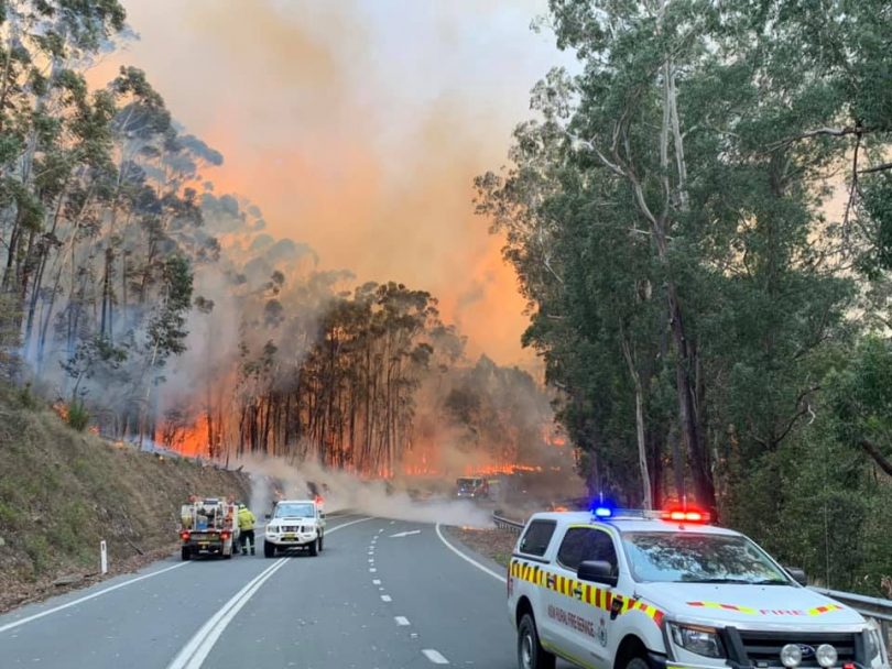
The Kings Highway west of Nelligen this week. Photo: Ulladulla Fire and Rescue.
Increased fire activity on the Clyde Mountain continues to make conditions dangerous, with police saying the Kings Highway will remain closed for the foreseeable future.
The Currowan bushfire continues to burn north of the highway and was listed as an emergency-level fire at 12:30 pm (19 December).
“There is still active fire in the areas around Benandarah, Windywoppa, Currowan and on the northern side of the Kings Highway. Crews continue to conduct backburning operations to strengthen containment lines along the Kings Highway,” the NSW Rural Fire Service website reported this morning (19 December).
The fire has also moved into Monga National Park in the shire’s north-west.
“I want the community to be prepared. There’s potential for serious fire impacts over the weeks and months ahead,” Eurobodalla shire mayor Liz Innes said.
“Firefighters are working in appalling conditions on steep and heavily forested terrain, up to Government Bend. It’s taken a massive effort to keep the fire contained so far.”
“It’s safety first, and that’s why Transport NSW has closed the Kings Highway,” Ms Innes said.
There are roadblocks to the east of Braidwood on the Kings Highway and at Nelligen. The Araluen Road has also been closed and there are roadblocks west of Moruya and out of Braidwood.
A new fire – the Tianjara Fire – was listed by the RFS as an emergency level fire at 12:05 pm on 19 December.
It forced the closure of the Braidwood/Nerriga road at 8:12 am. The road is closed in both directions between Turpentine Road and Oallen Road.
“Fire activity is increasing on the southern side of Braidwood Road at Tianjara. The fire may impact Wandandian, the Princes Highway and access to and Sussex Inlet today,” the RFS website said.
“There is the potential for the fire to reach Tianjara Prohibited Area which contains substantial unexploded ordinance. This will limit suppression activities.”
The former Tianjara Artillery Training Area near Sassafras, between Nerriga and Nowra, covers 8000 hectares.
The area was used for military training in the 1940s. In 2012, for the first time, the range was identified by the Department of Defence as a contaminated site.
The Currowan Fire has now burned more than 100,000 hectares.

Road closures on Live Traffic NSW as on 19 December. Image: Live Traffic NSW.
Brad Collins from the NSW RFS says the Currowan Fire is only 40 per cent contained.
“There were a few hairy moments yesterday (18 December) when there was a spot over the Kings Highway and things aren’t looking good for tomorrow (19 December) as we will see some strong north-westerly winds come through at 80–85 km/h in the early hours of the Thursday morning,” Mr Collins says.
“In the north-east sector, the fire may even get into the back of Milton, Ulladulla and Burrill Lake,” he says.
“Potentially, there will be embers and smoke in those areas.”
Mr Collins said he is “hopeful that the containment lines will hold, but there’s no guarantee”.
With the economies of Braidwood and the Far South Coast reliant on the summer tourist trade, the closure of the Kings Highway has an instant impact.
“The reality is we’re only a few weeks into summer. There’s no rain predicted and hot weather is only going to make conditions drier and more uncertain,” Ms Innes said.
“Emergency agencies managing this fire are acutely aware of the impact of highway closures on Eurobodalla’s economy. Our businesses are already under the hammer and realistically that looks set to continue while the Kings remains shut.
“The economic impact and the stress and uncertainty right on Christmas is tough. But together – being strong, caring for each other, and most of all, being prepared – we will get through this.”
Access to the coast from Canberra will be limited this summer. The route via Bungendore to Tarago is open, but travel from Nerriga to Nowra is no longer possible due to closure of the Braidwood/Nerriga road at Tianjara.
Many are using the Monaro and Snowy Mountains Highway via Cooma and Bemboka and turning north at Bega, which covers 369 km and takes around five hours.
To stay up to date with all NSW bushfires, check the NSW RFS website, listen to your local radio station, or call the NSW RFS Bush Fire Information Line on 1800 679 737.