20 April 2012

Kings Highway closed at Pooh Corner following massive landslide

| johnboy
Join the conversation
58
landslide

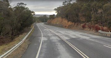
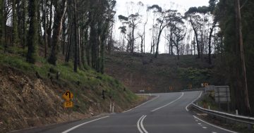
The NSW RTA is showing the Kings Highway closed at Pooh Corner in both directions due to a landslide.

They advise taking the Illawarra or Snowy Mountains Highways as alternative if you’re heading to the coast this weekend.
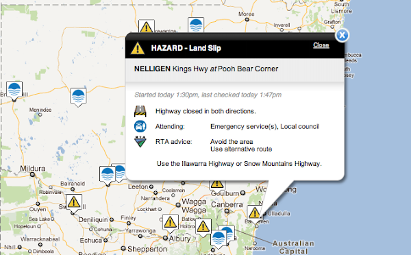
screenshot

UPDATE: 20/04/12 14:07: The Bay Post reports the road will be closed for some time:

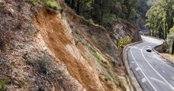
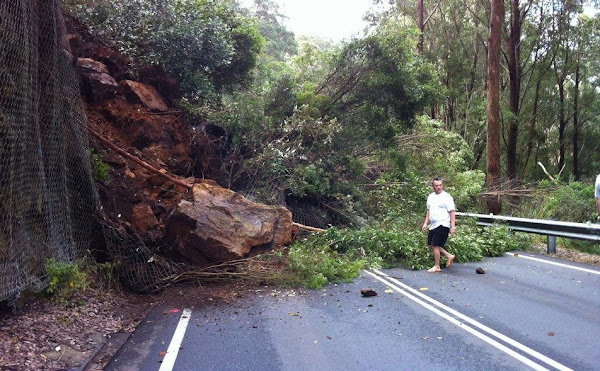
Both lanes of the Kings Highway are completely blocked with rubble and trees after a huge landslide on the Clyde Mountain.
Police are advising only Nelligen residents should use the Kings Highway as it is expected the highway will be closed for some time.

It is believed the cliff landslide occurred at about 1.30pm this afternoon, about 400m west of Pooh Bear corner.

It is not known at this stage if anyone is injured or any vehicles are trapped amongst the rubble, but police have inspected the site and say there are no obvious signs anyone is trapped.

[Photo posted to Facebook by Douglas J Robinson]

Join the conversation

58
All Comments
  • All Comments
  • Website Comments
LatestOldest

Geostorm said :

Does anyone know is the Oallen Crossing that crosses the Shoalhaven river from Tarago to Nerriga is flooded? Just curious if my little car will still make it. I enjoy that way, its quite scenic and there’s only a little bit of unsealed road.

It’s all fine. Our car may be a bit bigger by the sound of things, but I don’t think you’ll have any problems with water. (We drove that way this afternoon, so if there are massive rains, you’ll have to check again.) It is a very beautiful road, so in a way the landslide did us a favour, making us try this road on the way back, and the Araluen road on the way down.

Note that Araluen road is now closed but to local residents only… . No signs until you get there. I then had to head all the way Nerriga road… just wish they w I would have put signs up when leaving Bungendore!!

Does anyone know is the Oallen Crossing that crosses the Shoalhaven river from Tarago to Nerriga is flooded? Just curious if my little car will still make it. I enjoy that way, its quite scenic and there’s only a little bit of unsealed road.

p1 said :

HenryBG said :

thatsnotme said :

I don’t think the ‘lighting never hits the same spot twice’ rule applies here – the piece of land that guy’s standing underneath is now weaker than it was before.
.

Nope. It is now more stable. A considerable amount of mass which was either adjacent to or above it is now below it.

Sure, he is less likely to be buried under 100 tonne of rock. But the one cricket ball sized one is still more likely to bounce down and scone his noggin there, then on any other randomly selected metre of road in NSW that day, in my opinion.

The whole area has just been subjected to the considerable vibration caused by the downward motion of several hundred tonnes of material. Any material that *was* in a precarious state was brought down by that vibration, making your cricket-ball scenario *less* likely the closer you get to the epicentre of the landslide.

Of course, when they start trying to move it all off the road, they create new instability, but until they do that, one of the most stable parts of the entire descent is at the location of the latest gravity-assisted adjustment.

I have great issues with bureaucratic decision-making that is informed by the same kind of thought-processes. It’s very common.
Even trained professionals like GPs have been found to be responsible – on average – for a 50% rate of non-evidence-based opinions, so I don’t hold out great hope for bureaucrats to become sensible any time soon, not until we get our technocratic revolution, anyway.

Helpful driving hints from a real bush expert: If you are looking for the road to Nerriga to come back to Canberra, and your GPS says turn left several kilometres before where you thought you should turn, and you’re suspicious, but you think, oh well, who am I to argue with a machine with an American accent, well, you will find yourself on a fire-trail, surrounded by strange black wallabies and in danger of breaking an axle. There will be lots of clay and small creeks across the road. You will begin to think of Ivan Milat and shallow graves.

Ignore your GPS! Look for Turpentine Road with your Own Eyes! Only years of wearing pastel striped shirts and voting National will usually bring you to this level of bush-craft.

HenryBG said :

thatsnotme said :

I don’t think the ‘lighting never hits the same spot twice’ rule applies here – the piece of land that guy’s standing underneath is now weaker than it was before.
.

Nope. It is now more stable. A considerable amount of mass which was either adjacent to or above it is now below it.

Sure, he is less likely to be buried under 100 tonne of rock. But the one cricket ball sized one is still more likely to bounce down and scone his noggin there, then on any other randomly selected metre of road in NSW that day, in my opinion.

thatsnotme said :

I don’t think the ‘lighting never hits the same spot twice’ rule applies here – the piece of land that guy’s standing underneath is now weaker than it was before.
.

Nope. It is now more stable. A considerable amount of mass which was either adjacent to or above it is now below it.

poetix said :

Araluen Road is able to be driven in a rear wheel drive car. Rough, wet and scary, and Mr Poetix nearly soiled himself, but it can be done. Do not try it at night though.

It takes forever, too.

i have done Araluen road, in a 4wd, front wheel drive corrolla and a bicycle….easily passable if it is dry

HenryBG said :

Cheap said :

Doesn’t seem very safe to stand right next to the landslide

Not very logical.
This unstable bit of ground has found a new and more stable configuration. By definition, this spot is safer than many other spots with instability not yet sufficient to trigger a slide.
Sadly, we see your sort of logic employed all the time by bureaucratic decision-makers.

The “shut the gate after the horse has bolted” cliche was invented to describe this (fairly dim) approach to risk management.

Really? There’s no chance that the bit of slope right next to the part that hasn’t slipped suddenly not being there any more would cause that stable part to be more prone to slipping?

I don’t think the ‘lighting never hits the same spot twice’ rule applies here – the piece of land that guy’s standing underneath is now weaker than it was before.

If this guy wanted to stand in a safe spot, he’d be better off standing in the branches of the trees already on the road.

HenryBG said :

goggles13 said :

SnapperJack said :

The good thing about this is thinking about all those pubes who took flexidays and leave on Monday and Tuesday hoping to have an extended long weekend at the coast.

Don’tcha just love the RTA saying it will take three days to reopen the highway? Maybe the shinybums will take more leave on Thursday and Friday. Perhaps they should stay on holiday permanently. Nobody will notice the difference.

is it really necessary to have a dig at public servants?
.

Yes.

And next time he’s thrown in a cell in Bali after a drunken spat with a member of the local constabulary, he will have another dig at how long it takes the public servants at DFAT to save his bacon.

What manner of gibberish is that last para please HBG? The bloke in the photo?

goggles13 said :

is it really necessary to have a dig at public servants?

I suspect that people in the private sector may also turn a mid-week public holiday into a long weekend.

I suspect that many Canberrans who were down there for the school holidays (whether their parents are public or private servants) will be affected too. Looking at the general demographic of those who regularly travel down there, public servants are a fairly small portion.

The generic bogan with a 4wd and boat is more likely to be found, especially given that theyll get their centrelink pay early cos of the public holiday.

HenryBG said :

Cheap said :

Doesn’t seem very safe to stand right next to the landslide

Not very logical.
This unstable bit of ground has found a new and more stable configuration. By definition, this spot is safer than many other spots with instability not yet sufficient to trigger a slide.
Sadly, we see your sort of logic employed all the time by bureaucratic decision-makers.

The “shut the gate after the horse has bolted” cliche was invented to describe this (fairly dim) approach to risk management.

Yes, because the landslides in that part of the country are very efficient, with every possible rock having fallen to its lowest possible energy state at the time of the slide. There is zero chance of a small rock rolling down and hitting he guy in the head.

goggles13 said :

SnapperJack said :

The good thing about this is thinking about all those pubes who took flexidays and leave on Monday and Tuesday hoping to have an extended long weekend at the coast.

Don’tcha just love the RTA saying it will take three days to reopen the highway? Maybe the shinybums will take more leave on Thursday and Friday. Perhaps they should stay on holiday permanently. Nobody will notice the difference.

is it really necessary to have a dig at public servants?
.

Yes.

And next time he’s thrown in a cell in Bali after a drunken spat with a member of the local constabulary, he will have another dig at how long it takes the public servants at DFAT to save his bacon.

SnapperJack said :

The good thing about this is thinking about all those pubes who took flexidays and leave on Monday and Tuesday hoping to have an extended long weekend at the coast.

Don’tcha just love the RTA saying it will take three days to reopen the highway? Maybe the shinybums will take more leave on Thursday and Friday. Perhaps they should stay on holiday permanently. Nobody will notice the difference.

is it really necessary to have a dig at public servants?

I suspect that people in the private sector may also turn a mid-week public holiday into a long weekend.

IrishPete said :

Canberras Times now reporting that Aarluen Road is also closed in both directions:

I travelled up the Araluen Rd yesterday and it was fairly degraded. There were many places with water over the road and many big 4wds travelling way too fast for the conditions chewing up the road. Noticably, many of them had ACT plates. In a couple of areas the road had subsided, making it virtually impossible for one car to pass another as the road was barely wide enough.

There were also quite a number of ACT falcons pulling boats and trailers down the road, which no doubt would have been fun when they came across another vehicle in the unpassable areas and no doubt contributed to the road being closed.

poetix said :

BiffLoman said :

I’ve always wondered whether Nelligen is pronounced with a hard or soft ‘g’. Many thanks.

It’s pronounced with a hard ‘g’. That’s how the locals in the Steampacket say it.

Thanks, poetix.

Interesting that the landslip has cut off the road in that exact spot – because of course the Pooh Corner “grotto” is part of an underground tunnel that was to be blown up and block the Japanese if they headed up from the coast toward Canberra …

Cheap said :

Doesn’t seem very safe to stand right next to the landslide

Not very logical.
This unstable bit of ground has found a new and more stable configuration. By definition, this spot is safer than many other spots with instability not yet sufficient to trigger a slide.
Sadly, we see your sort of logic employed all the time by bureaucratic decision-makers.

The “shut the gate after the horse has bolted” cliche was invented to describe this (fairly dim) approach to risk management.

Cheap said :

Doesn’t seem very safe to stand right next to the landslide

with no footwear or any other protective clothing…

IP

Canberras Times now reporting that Aarluen Road is also closed in both directions: http://www.canberratimes.com.au/act-news/kings-hwy-landslide-forces-canberrans-to-change-plans-20120421-1xece.html

IP

BiffLoman said :

I’ve always wondered whether Nelligen is pronounced with a hard or soft ‘g’. Many thanks.

It’s pronounced with a hard ‘g’. That’s how the locals in the Steampacket say it.

The good thing about this is thinking about all those pubes who took flexidays and leave on Monday and Tuesday hoping to have an extended long weekend at the coast.

Don’tcha just love the RTA saying it will take three days to reopen the highway? Maybe the shinybums will take more leave on Thursday and Friday. Perhaps they should stay on holiday permanently. Nobody will notice the difference.

I’ve always wondered whether Nelligen is pronounced with a hard or soft ‘g’. Many thanks.

Doesn’t seem very safe to stand right next to the landslide

and with the main bridge into Captains Flat closed to vehicles over 5T, because it’s a bit fragile at the moment, we’re probably not the best detour either. If you want to use the Araluen Road, quicker go to Braidwood on the highway, and to Araluen on sealed roads, rather than via Captains Flat which has lots of unsealed roads, and I’m not sure of the condition of the Majors Creek Mountain Road, which was closed a month or so ago, from (wait for it) landslide…

IP

And the ABC News does a superb job – NOT. Although ABC News advises me that TV and radio refer to this event there is absolutely nothing on the news website. I am advised that there is no producer available and no ability to fix. Reminds me of the time when the Barton Highway was closed for three hours including peak time on a Friday night due a major accident and the only news I could find was that two ladies in Deakin had been in a minor accident and taken to Canberra Hospital for checking.

Of course other Canberra news sources also suck – I have had the Canberra Times report on another accident in the PRINT edition and nothing on their web site. Not this time though – getting better?

We drove down Brown mountain last night. Totally clear, apart from an old granny driviving down it at 3 kph! Kil,, kill,, kill!!!!

Yesterday afternoon we came to Jervis Bay via Tarago, then going through Nerriga. The Shoalhaven was pretty high at the crossing (the car behind us stopped to see if we got through first before they started) and turning ont the road that goes through Nerriga there was a lot of traffic – at the turn-off turning right onto the Princes highway from the 9km dirt road bit, the line of cars was 1km – would be nice if they had temporary traffic lights as you are turning right into a 100km zone and there is no turning lane.

johnboy said :

brown mountain is open again, but not sure you’d trust it until things dry out a bit.

Nerriga Road has 18km unsealed still. In these conditions I’d not recommend it to the inexperienced.

If you go Bungendore/Tarago/Nerriga there is only about 3km of dirt road which has been graded to perfection ready for sealing last time I went through.

As for the Araluen Rd, that used to be the Clyde alternative before the Nerriga Rd had $80million spent on it. I grew up down there (and learnt to drive on that road) and whenever the Clyde got closed due to accident you would have a steady stream in both directions. 20kph may be a bit overcautious, you just need to keep left and slow down a bit for the really blind corners. Our cars were always 2wd vans and handled the 50km of dirt in about 45 mins no worries. Might be a bit more traffic this weekend though.

EvanJames said :

Is Brown Mountain still closed? RTA thing seems to suggest it isn’t. The crazed Canberra drivers will NOT like the Nerriga Route, I think part of it still has (gasp) DIRT! And everyone knows, these days you can’t drive on DIRT unless you have a 4WD.

But taking the 4wd on the dirt might make it all mucky

poetix said :

vulpior said :

I know that when I was first here on holiday in 1996 we took the Kings Highway down to the Bay, but on the way back we drove south towards Moruya and then via Araluen. It’s certainly not very obvious as a route if you look high level at Google Maps, and I remember it was certainly not sealed.

Most is still unsealed. There are currently parts where water runs over the road to near the top of your wheels. Any more rain and it could become too dangerous. There could well be a rock-slide, or a tree falling. And as p1 pointed out, it is is very narrow. There is sometimes a sheer drop from the edge of this narrow road.

But if you put on fake American red-neck voices and don’t mind the trip to the coast taking about twice as long as normal, it’s just lovely.

I love that road. But I have to drive 20kph the whole way just to stay on the road and be prepared for the locals in their 4WDs coming round the bends. And that’s when it’s dry! I wouldn’t attempt it in the wet, I think.

Last time I drove that road I met some locals who were convinced I was lost and kept trying to redirect me to the highway. I can understand why. It’s not a shortcut if you drive an Astra. But so pretty!

johnboy said :

brown mountain is open again, but not sure you’d trust it until things dry out a bit.

Nerriga Road has 18km unsealed still. In these conditions I’d not recommend it to the inexperienced.

Brown Mountain was fine last weekend. Not sure whether the rain during the week has changed that, but we had a beautiful drive from Canberra to Bega last Sunday.

vulpior said :

I know that when I was first here on holiday in 1996 we took the Kings Highway down to the Bay, but on the way back we drove south towards Moruya and then via Araluen. It’s certainly not very obvious as a route if you look high level at Google Maps, and I remember it was certainly not sealed.

Most is still unsealed. There are currently parts where water runs over the road to near the top of your wheels. Any more rain and it could become too dangerous. There could well be a rock-slide, or a tree falling. And as p1 pointed out, it is is very narrow. There is sometimes a sheer drop from the edge of this narrow road.

But if you put on fake American red-neck voices and don’t mind the trip to the coast taking about twice as long as normal, it’s just lovely.

aussielyn said :

Any news about Pooh Bear himself. Is he OK?
Is he injured & trapped inside his cave, dare I say it, entombed?

Shhhhh……… if we listen carefully, we might hear him tapping out an SOS on all those empty Bundy bottles.

Araluen Rd, I forgot about that. Evil RTA people at Braidwood could have some fun pointing their detour signs right, rather than left to Nerriga! Imagine the crazed ACT loons being confronted with that, oh my. Or better still, diverting them as they exit Quangers, via Captains Flat.

I know that when I was first here on holiday in 1996 we took the Kings Highway down to the Bay, but on the way back we drove south towards Moruya and then via Araluen. It’s certainly not very obvious as a route if you look high level at Google Maps, and I remember it was certainly not sealed.

poetix said :

Araluen Road is able to be driven in a rear wheel drive car. Rough, wet and scary, and Mr Poetix nearly soiled himself, but it can be done. Do not try it at night though.

It takes forever, too.

It gets pretty slow with all the turns to follow the river, and isn’t quick. Take it easy on the bends – remember there may be someone coming the other way…

Araluen Road is able to be driven in a rear wheel drive car. Rough, wet and scary, and Mr Poetix nearly soiled himself, but it can be done. Do not try it at night though.

It takes forever, too.

Good thing that wire mesh was there to stop it.

Any news about Pooh Bear himself. Is he OK?
Is he injured & trapped inside his cave, dare I say it, entombed?

Can always go via Moss Vale/Kangaroo Valley if you are not heading somewhere on the far south coast.

I drove past on Thursday and noticed a minor slip. Didn’t think there had been enough rain to cause a major slip, but maybe it has all accumulated over the past few months and made the ground unstable.

Does anyone know what the Murrays service to/from the coast will be doing? Running/not running, and if running, what route?

johnboy said :

Nerriga Road has 18km unsealed still. In these conditions I’d not recommend it to the inexperienced.

It saddens me that many of the drivers on out roads might be sufficiently poor at operating a motor vehicle that they cannot, will not, or should not consider attempting 18km of unsealed road.

Having said that, I am happier the less other people are on a road with me, so would like to suggest a few other roads that could be converted to dirt.

VYBerlinaV8_is_back3:55 pm 20 Apr 12

johnboy said :

Nerriga Road has 18km unsealed still. In these conditions I’d not recommend it to the inexperienced.

There’s two things you need to remember when you drive on difficult roads:
1) Go slowly – slow enough that you can comfortably stop well within sight.
2) If traffic builds up behind you, pull over and let them go.

Obviously use gentle control inputs to reduce the risk of sliding.

Gungahlin Al said :

johnboy said :

floods, earthquakes, fog, now cut off from The Bay.

Surely the zombie apocalypse is next?

Connect the dots – this WAS the earthquake. You all thought you got off scott-free, but now your beach weekend is tantalisingly out of reach. It’s God’s way of punishing us all for turning out in such huge numbers to see that pagan Richard Dawkins.

It’s most likely the last Indian Summer warm weekend, too. Anzac day sees the colder air arrive, bringing us to more seasonably-appropriate temperatures.

johnboy said :

Nerriga Road has 18km unsealed still. In these conditions I’d not recommend it to the inexperienced.

This should be good. Might be worth grabbing a deck chair and esky and heading off to watch the fun!

I was overtaken by a local in an Excel on the dirt bit many years ago, he was absolutely caning along. I was impressed.

Gungahlin Al3:21 pm 20 Apr 12

johnboy said :

floods, earthquakes, fog, now cut off from The Bay.

Surely the zombie apocalypse is next?

Connect the dots – this WAS the earthquake. You all thought you got off scott-free, but now your beach weekend is tantalisingly out of reach. It’s God’s way of punishing us all for turning out in such huge numbers to see that pagan Richard Dawkins.

bitzermaloney3:21 pm 20 Apr 12

With the Brown Mountain pass also closed isn’t it about time the NSW grubbymint think about at least ONE reliable highway down the mountain?

Is Brown Mountain still closed? RTA thing seems to suggest it isn’t. The crazed Canberra drivers will NOT like the Nerriga Route, I think part of it still has (gasp) DIRT! And everyone knows, these days you can’t drive on DIRT unless you have a 4WD.

brown mountain is open again, but not sure you’d trust it until things dry out a bit.

Nerriga Road has 18km unsealed still. In these conditions I’d not recommend it to the inexperienced.

i have a photo of the landslide but not sure how to post it?

Gee, the NSW RMS is now officially calling the area Pooh Bear’s Corner.

I always thought that was just a nickname used by holidaying public servants from Canberra.

Queensland had a landslide recently too, but they didn’t shut it down…

Going through Nerriga only adds 30km to a trip to Ulladulla (considerably more to the Bay though….

The Very Serious Issue™ that you haven’t addressed though JB, is – Did Pooh Bears Cave survive the landslip??!!

floods, earthquakes, fog, now cut off from The Bay.

Surely the zombie apocalypse is next?

oh d-d-d-dear.

Daily Digest

Want the best Canberra news delivered daily? Every day we package the most popular Riotact stories and send them straight to your inbox. Sign-up now for trusted local news that will never be behind a paywall.

By submitting your email address you are agreeing to Region Group's terms and conditions and privacy policy.