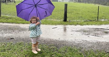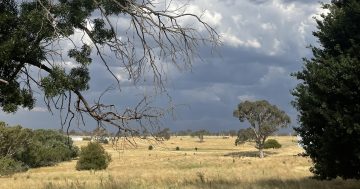
Expect a wet weekend across the region, especially on Sunday, with possible snowfall early next week. Photo: Michelle Kroll.
The region will be awash with rain, thunderstorms and possible snowfalls as a band of low-pressure systems move across NSW and the ACT this weekend and early next week.
While there won’t be any return to winter temperatures, the trough will start to move across NSW on the weekend, bringing the risk of severe thunderstorms to the ACT region on Monday.
There’s good news for farmers, where parts of central Australia could see a season’s worth of rain, especially in the NSW far west town of Broken Hill where it remains very dry. Models suggest that widespread accumulated totals of 20 to 40 mm are likely, with isolated falls over 50 mm. Some of this rain will be falling in outback areas that average about 30 to 50 mm during all of spring.
There is also a good chance of snow falling in the Snowy Mountains down to 1300 metres next Tuesday and Wednesday, but it is expected to be fairly slushy due to the preceding rain.
The Bureau of Meteorology (BOM) says the trough will linger in NSW and the ACT during the weekend, bringing showers to most areas. Between 15 and 25 mm of rain is forecast for Canberra on Sunday and Monday.
Severe thunderstorm warnings could also be issued over the weekend.
BOM Helen Kirkup said there is a lot of moisture in the air and the troughs will bring the first indications of summer thunderstorm activity.
“We’ve got a broad low-pressure trough across inland Australia, and as this moves over we are expecting to see some gusty winds and the potential for thunderstorms in the far west of NSW on Saturday,” Ms Kirkup said.
“As the trough goes through, it does have the potential for severe thunderstorms with this system. Winds will change from quite warm northerlies to south-westerlies behind it.
“There will be rain falling in the ACT and it looks like Sunday and Monday are the main days for that.
“In general, it will be a very broad, showery system, so the amounts of rainfall will be fairly varied across the state,” she said.
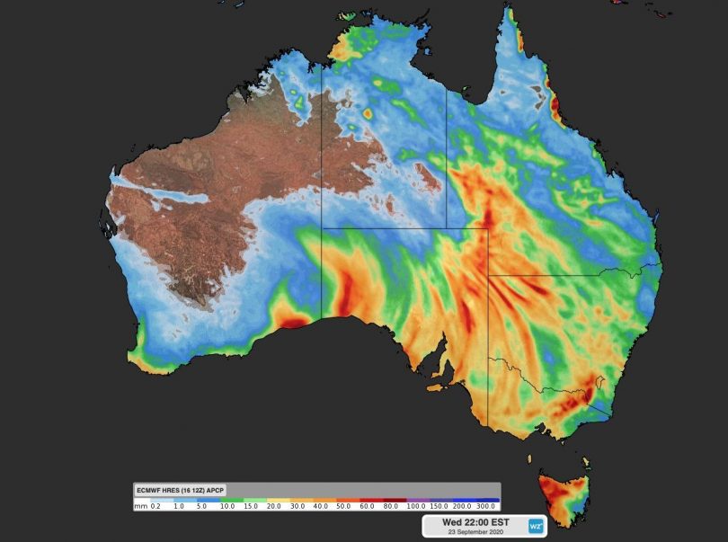
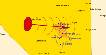
The forecast rainfall up to next Wednesday (23 September). Image: Weatherzone.
Ms Kirkup said it is likely that weather warnings will be issued once the system approaches the areas likely to be affected.
On the NSW South Coast, she said the forecast is that rainfall will be sporadic at best, with lower totals than that expected inland and only a 50 per cent chance of rain.
In the Snowy Mountains, snow is forecast to fall down to 1600 metres next Tuesday (22 September) and 1300 metres on Wednesday.
“The snow looks likely with a cold air mass after the rainfall, so it could be fairly mushy for skiers and not very large totals of snow,” Ms Kirkup said.
In Canberra, Sunday and Monday will be the wettest, with the chance of thunderstorms and persistent rain.
“Monday is looking like the main day for thunderstorms in the ACT, with convective, summery conditions and strong wind gusts.
“I don’t expect the temperatures will get below the low 20s on Saturday, almost 20 on Sunday and warming up again on Monday with a top of 23 degrees. Tuesday and Wednesday next week will be cooler with a forecast of 17 and 16 degrees,” Ms Kirkup said.
She said the highest September temperature in Canberra was 28 degrees in 1965, but the average of temperatures in the month was already in the highest decile above 21 degrees.
While the BOM has yet to formally declare a La Niña, where multiple days of rain and storm events are more prevalent, a distinct La Niña-like pattern is likely having an influence on the coming week’s weather.
“Sea surface temperatures over the western tropical Pacific Ocean are currently more than one degree warmer than average for this time of year, which is putting more moisture into the atmosphere through evaporation,” said Weatherzone meteorologist Ben Domensino.
“With La Niña expected to become more consolidated in the Pacific Ocean during the coming months, large parts of Australia can expect to see above-average rain this spring.”